| Mesoscale Discussion 41 | |
| < Previous MD | |
|
|
Mesoscale Discussion 0041
NWS Storm Prediction Center Norman OK
0554 AM CST Sat Jan 24 2026
Areas affected...Southern Kentucky...Western and Middle
Tennessee...Far Northern Alabama...Far Northern Mississippi
Concerning...Winter mixed precipitation
Valid 241154Z - 241800Z
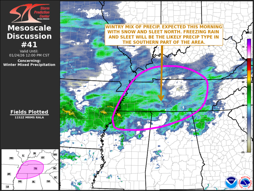
SUMMARY...A mix of wintry precipitation is expected this morning
from the Mid-South northeastward into Tennessee and southern
Kentucky, where snow, sleet and freezing rain will be possible this
morning.
DISCUSSION...The latest mosaic radar imagery across the southeastern
U.S. shows a large area of precipitation from Arkansas extending
eastward to the southern Appalachians. This precipitation is being
supported by strong lift associated with the right entrance region
of an expansive mid-level jet, and by ascent due to a 40 to 50 knot
low-level jet over the lower to mid Mississippi Valley. The nose of
the low-level jet will move east-northeastward across the Mid-South
and Tennessee Valley this morning, contributing to the maintenance
of widespread precipitation. RAP forecast soundings across the
region have a warm nose from 900 to 700 mb, where temperatures are
forecast to gradually warm to near 0 C after daybreak this morning.
This will result in a wintry mix of precipitation. Snow may continue
in parts of southern Kentucky through midday. However, further south
into western and middle Tennessee, a transition to sleet and
freezing rain will be likely. In far northern Mississippi and far
northern Alabama, the predominant precipitation type will be
freezing rain.
..Broyles/Mosier.. 01/24/2026
...Please see www.spc.noaa.gov for graphic product...
ATTN...WFO...MRX...JKL...FFC...LMK...OHX...BMX...HUN...PAH...
MEG...
LAT...LON 34218753 34058865 34038945 34049004 34139036 34289047
34779050 35858990 36778909 37238805 37328683 37228592
36928511 36488459 35628468 35068514 34588614 34228742
34218753
|
|
|
Top/All Mesoscale Discussions/Forecast Products/Home |
|
Source link