

| Mesoscale Discussion 2426 | |
| < Previous MD | |

|
|
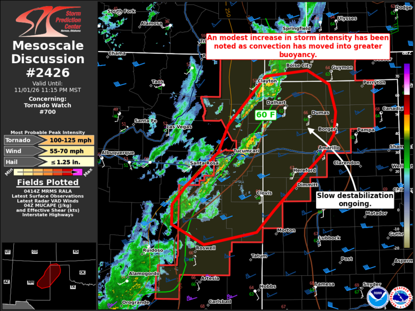
Mesoscale Discussion 2426 NWS Storm Prediction Center Norman OK 1017 PM CST Sun Nov 01 2026 Areas affected...East-central New Mexico into the western Texas/Oklahoma Panhandles Concerning...Tornado Watch 700... Valid 020417Z - 020615Z The severe weather threat for Tornado Watch 700 continues. SUMMARY...Tornadoes and severe wind gusts will continue to be a concern into the overnight hours as convection moves into far eastern New Mexico and the Texas Panhandle/South Plains. DISCUSSION...Lightning activity has increased with a small linear segment near Tucumcari, NM. This has occurred as convection has deepened within the axis of greater MUCAPE along the TX/NM border. To the east of this activity, moisture has remained in the low 60s F with temperatures in the Texas Panhandle actually increasing by a degree or two F over the last hour. This modest warming coupled with cooling aloft has allowed destabilization to spread eastward this evening. Linear segments that can intensify will move within an environment of strong low-level shear--VAD data from KFDX and KAMA show 0-500 m SRH of 300-350 m2/s2. QLCS and perhaps isolated supercell tornadoes are possible into the overnight hours. Strong to severe wind gusts can also be expected even with modest convection given the strength of the low-level flow field. The main uncertainty is how far south stronger convection can form as mid-level ascent is weaker with southward extent. ..Wendt.. 11/02/2026 ...Please see www.spc.noaa.gov for graphic product... ATTN...WFO...LUB...AMA...ABQ... LAT...LON 33510433 33880504 34230504 34550476 35210402 35700382 36590298 36690203 36430155 35930141 35520146 35170170 34820209 34140279 33740317 33510433 MOST PROBABLE PEAK TORNADO INTENSITY...100-125 MPH MOST PROBABLE PEAK WIND GUST...55-70 MPH MOST PROBABLE PEAK HAIL SIZE...UP TO 1.25 IN |
|
|
Top/All Mesoscale Discussions/Forecast Products/Home |
|
Source link