

| Mesoscale Discussion 2422 | |
| < Previous MD Next MD > | |

|
|
   Mesoscale Discussion 2422
   NWS Storm Prediction Center Norman OK
   0334 PM CST Sun Nov 01 2026

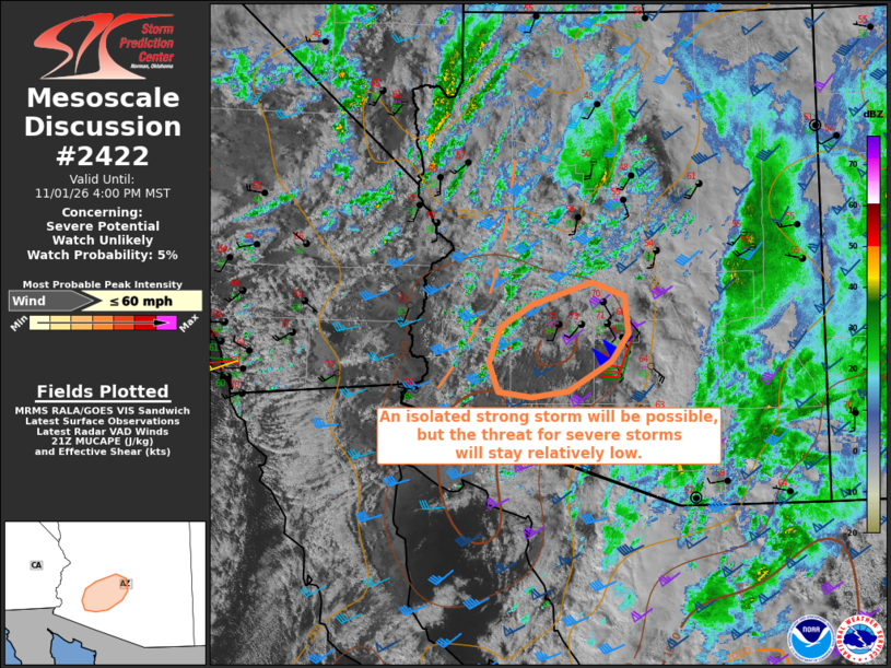
   Areas affected...Southwest Arizona

   Concerning...Severe potential...Watch unlikely

   Valid 012134Z - 012300Z

   Probability of Watch Issuance...5 percent

   SUMMARY...An isolated strong storm will be possible, but the overall
   severe threat should remain relatively low.

   DISCUSSION...Surface temperatures are warming into the low-mid 70s
   within cloud breaks across southwest AZ, and deepening cumulus is
   noted along a deep-layer confluence zone coincident with a
   subtropical shortwave trough ejecting quickly east-northeastward
   over southwest AZ.  A couple more hours of surface heating is
   possible prior to passage of the shortwave trough and associated
   low-level cooling/drying occurs.  A tendency for warming midlevel
   temperatures from the west and the low-level cooling will limit the
   magnitude of and the spatial and temporal window for destabilization
   from southwest into south central AZ.  In the interim, a strong,
   low-topped storm will be possible along the confluence band with
   low-end potential for strong convective gusts given strong midlevel
   flow and long hodographs.

   ..Thompson/Gleason.. 11/01/2026

   ...Please see www.spc.noaa.gov for graphic product...

   ATTN...WFO...PSR...

   LAT...LON   33311172 32991196 32641255 32571304 32631349 32961362
               33371348 33641305 33891221 33741177 33311172

   MOST PROBABLE PEAK WIND GUST...UP TO 60 MPH
|
|
|
Top/All Mesoscale Discussions/Forecast Products/Home |
|
Source link