

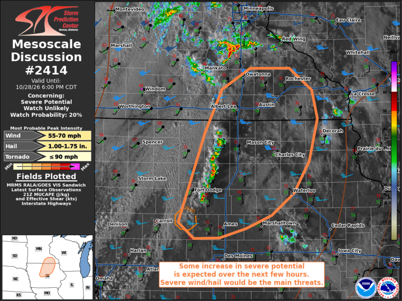
| Mesoscale Discussion 2414 | |
| < Previous MD | |

|
|
   Mesoscale Discussion 2414
   NWS Storm Prediction Center Norman OK
   0427 PM CDT Wed Oct 28 2026

   Areas affected...portions of central and northern Iowa into
   southeastern Minnesota

   Concerning...Severe potential...Watch unlikely

   Valid 282127Z - 282300Z

   Probability of Watch Issuance...20 percent

   SUMMARY...The threat for at least isolated severe wind and hail will
   accompany intensifying thunderstorms over central into northern IA.

   DISCUSSION...A line of thunderstorms has recently initiated
   immediately ahead of a surface pressure trough. Ahead of these
   storms, surface temperatures have warmed well into the 70s F, with
   at least upper 50s F dewpoints noted. With 7+ C/km mid-level lapse
   rates noted (per latest forecast soundings), MUCAPE has exceeded
   1000 J/kg well out ahead of the storms. Furthermore, these storms
   are progressing toward the core of a 40+ kt LLJ, supporting over 35
   kts of effective bulk shear and enlarged/curved low-level hodographs
   (per regional VADs). This kinematic and thermodynamic environment
   would support supercells capable of at least a severe wind/hail
   threat. However, some MLCINH remains, so some questions remain how
   widespread severe will become. Nonetheless, at least isolated
   instance of severe gusts/hail and perhaps a tornado are possible
   this evening.

   ..Squitieri/Guyer.. 10/28/2026

   ...Please see www.spc.noaa.gov for graphic product...

   ATTN...WFO...ARX...MPX...DMX...

   LAT...LON   42099443 43329396 43919365 44219311 44219238 43909196
               43519185 42939201 42499231 42209272 42019318 41899367
               41889415 42099443

   MOST PROBABLE PEAK TORNADO INTENSITY...UP TO 90 MPH
   MOST PROBABLE PEAK WIND GUST...55-70 MPH
   MOST PROBABLE PEAK HAIL SIZE...1.00-1.75 IN
|
|
|
Top/All Mesoscale Discussions/Forecast Products/Home |
|
Source link