

| Mesoscale Discussion 2406 | |
| < Previous MD | |

|
|
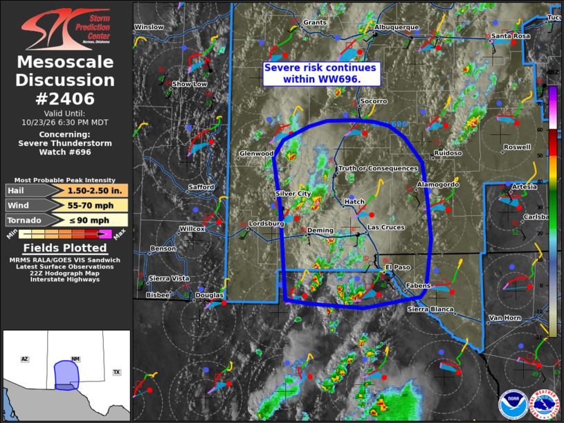
Mesoscale Discussion 2406 NWS Storm Prediction Center Norman OK 0534 PM CDT Fri Oct 23 2026 Areas affected...south-central New Mexico and far west Texas Concerning...Severe Thunderstorm Watch 696... Valid 232234Z - 240030Z The severe weather threat for Severe Thunderstorm Watch 696 continues. SUMMARY...Threat for large hail, severe wind, and perhaps a brief tornado continues within WW696. DISCUSSION...Supercells continue across southern New Mexico this afternoon, with several splits and supercell mergers ongoing. VAD profiles from ABX and EPZ depict linear and elongated hodographs, supporting continued splitting supercells. Winds aloft veer to southwesterly just off the surface. Surface observations near the Rio Grande Valley are more southeasterly. If the supercells/supercell clusters west of El Paso can deviate more strongly eastward, a slight increase in low-level SRH and potential for a tornado where dew points are near 50 F. Moisture becomes more limited with eastern and northern extent where dew points are more around the mid 40s F. Overall, the main threats will likely remain large hail and severe wind. ..Thornton.. 10/23/2026 ...Please see www.spc.noaa.gov for graphic product... ATTN...WFO...ABQ...EPZ... LAT...LON 32660817 33340829 33580814 33770771 33840741 33860699 33830664 33770638 33610614 33270585 32740576 32210572 31670578 31490582 31410589 31260682 31280722 31310767 31360808 32660817 MOST PROBABLE PEAK TORNADO INTENSITY...UP TO 90 MPH MOST PROBABLE PEAK WIND GUST...55-70 MPH MOST PROBABLE PEAK HAIL SIZE...1.50-2.50 IN |
|
|
Top/All Mesoscale Discussions/Forecast Products/Home |
|
Source link