

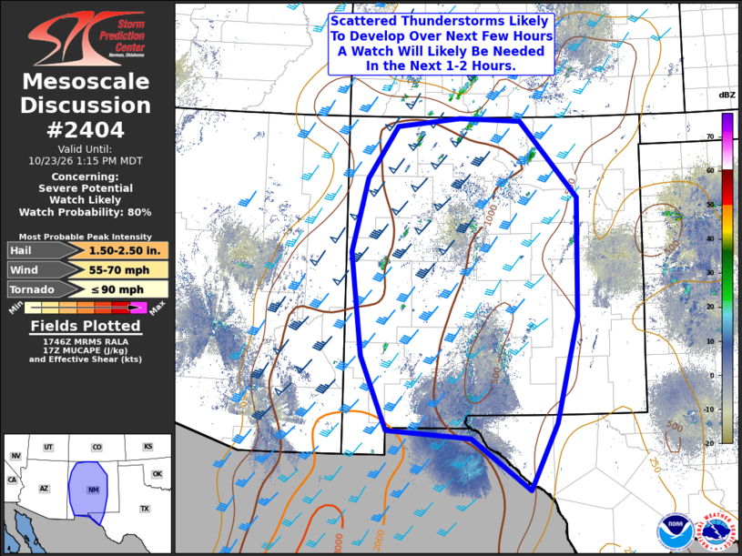
| Mesoscale Discussion 2404 | |
| < Previous MD | |

|
|
   Mesoscale Discussion 2404
   NWS Storm Prediction Center Norman OK
   1248 PM CDT Fri Oct 23 2026

   Areas affected...Much of New Mexico and Portions of Far West Texas

   Concerning...Severe potential...Watch likely

   Valid 231748Z - 231915Z

   Probability of Watch Issuance...80 percent

   SUMMARY...Thunderstorms are expected to develop this afternoon
   across the terrain of New Mexico. Strong vertical shear will support
   thunderstorm organization, with the potential for very large hail
   and damaging thunderstorm winds, and perhaps a tornado or two. A
   Severe Thunderstorm Watch will likely be needed later this
   afternoon.

   DISCUSSION...A seasonably moist airmass remains in place across much
   of the southern Rockies this afternoon, with surface dewpoints in
   the mid to upper 50Fs across central and western New Mexico. Cloud
   cover has been less than in previous days within the moist plume,
   allowing for temperatures to warm quickly into the 60Fs north to
   70Fs south. The result is a plume of increasing MUCAPE across the
   area, with values currently in the 1000-1500 J/kg range.

   The region is somewhat in between sources of larger-scale forcing
   for ascent with a shortwave trough well downstream across the
   northern Rockies and a secondary wave still developing upstream
   across California. The result is that initiation will likely rely on
   a combination of convective temperatures being reached and moist
   upslope flow in favored topographical areas. Current expectation is
   that initiation should increasingly occur over the next 1-2 hours
   with a gradual ramp up in intensity through mid-afternoon.

   Vertical shear on the order of 40-50 knots will support supercells
   with the potential for very large hail and the occasional
   severe/damaging thunderstorm outflow by mid afternoon. A tornado
   cannot be ruled out given the moist environment and the potential
   for supercells. However, modest low-level winds and predominantly
   straight hodographs should limit the overall tornado potential
   through the afternoon.

   A Severe Thunderstorm Watch will likely be needed within the next
   1-2 hours to account for this evolving threat.

   ..Marsh/Thompson.. 10/23/2026

   ...Please see www.spc.noaa.gov for graphic product...

   ATTN...WFO...MAF...ABQ...EPZ...

   LAT...LON   31740819 32980871 34710894 35960862 36840802 36970674
               36920550 35630435 33620438 31850481 30740534 31600652
               31740819

   MOST PROBABLE PEAK TORNADO INTENSITY...UP TO 90 MPH
   MOST PROBABLE PEAK WIND GUST...55-70 MPH
   MOST PROBABLE PEAK HAIL SIZE...1.50-2.50 IN
|
|
|
Top/All Mesoscale Discussions/Forecast Products/Home |
|
Source link