

| Mesoscale Discussion 2403 | |
| < Previous MD | |

|
|
   Mesoscale Discussion 2403
   NWS Storm Prediction Center Norman OK
   0743 PM CDT Thu Oct 22 2026

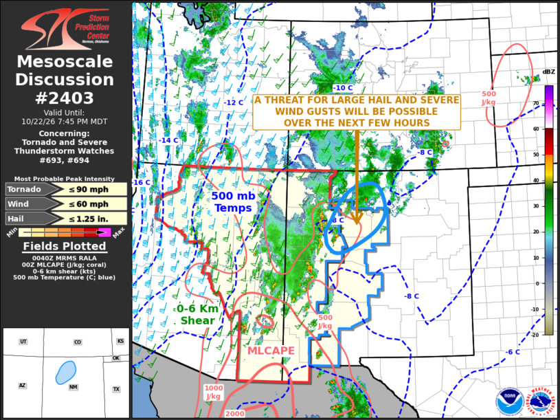
   Areas affected...Western and north-central New Mexico

   Concerning...Tornado and Severe Thunderstorm Watches 693...694...

   Valid 230043Z - 230145Z

   The severe weather threat for Tornado and Severe Thunderstorm
   Watches 693, 694 continues.

   SUMMARY...A threat for isolated large hail and a few severe wind
   gusts may continue for a couple more hours across parts of western
   and north-central New Mexico.

   DISCUSSION...Latest surface analysis shows what appears to be a
   surface trough extending north-northeastward across western and
   northern New Mexico. The RAP shows an axis of low-level convergence
   along and near the trough. This, along with topographic effects, has
   supported convective development this evening across western and
   northern New Mexico. Several strong to severe storms are ongoing
   near and just to the west of the trough, along which surface
   dewpoints are in the lower to mid 50s F and MLCAPE is estimated by
   the RAP around 500 J/kg. In addition, the latest VAD Wind Profiler
   near Albuquerque has 0-6 km shear around 30 knots with substantial
   mid-level speed shear. This, along with sufficiently steep mid-level
   lapse rates, will support rotating storms capable of isolated large
   hail. A few severe wind gusts will also be possible.

   ..Broyles.. 10/23/2026

   ...Please see www.spc.noaa.gov for graphic product...

   ATTN...WFO...ABQ...

   LAT...LON   35360774 35640758 36130730 36450697 36600664 36660624
               36570603 36380588 36030578 35690585 35290622 34860700
               34790738 34860755 35020770 35150773 35360774

   MOST PROBABLE PEAK TORNADO INTENSITY...UP TO 90 MPH
   MOST PROBABLE PEAK WIND GUST...UP TO 60 MPH
   MOST PROBABLE PEAK HAIL SIZE...UP TO 1.25 IN
|
|
|
Top/All Mesoscale Discussions/Forecast Products/Home |
|
Source link