

| Mesoscale Discussion 2402 | |
| < Previous MD | |

|
|
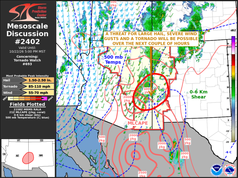
Mesoscale Discussion 2402 NWS Storm Prediction Center Norman OK 0501 PM CDT Thu Oct 22 2026 Areas affected...Eastern New Mexico...Western New Mexico Concerning...Tornado Watch 693... Valid 222201Z - 230000Z The severe weather threat for Tornado Watch 693 continues. SUMMARY...A threat for large hail, severe wind gusts and a tornado will be possible over parts of eastern Arizona and western New Mexico over the next couple of hours. DISCUSSION...Water vapor imagery currently shows an upper-level trough over California with southwesterly diffluent flow aloft over much of the Desert Southwest. The RAP shows a 60 to 80 knot mid-level jet moving through western Arizona. There appears to be a speed max at 700 mb moving through eastern Arizona, where a cluster of strong to severe storms is ongoing. These storms are forming near a pocket of moderate instability. The RAP has MLCAPE in the 1500 to 2500 J/kg range. Near the instability max, RAP forecast soundings early this evening have 0-6 km shear of 50 to 60 knots with long and relatively straight hodographs. This will be favorable for supercells with large hail. A tornado will also exist as low-level shear increases over the next couple of hours. The severe threat will move northeastward into the White Mountains of southwestern New Mexico later this evening. ..Broyles.. 10/22/2026 ...Please see www.spc.noaa.gov for graphic product... ATTN...WFO...ABQ...EPZ...TWC...FGZ...PSR... LAT...LON 32590979 32640907 33000836 33340793 33840780 34440791 34780817 34920873 34880915 34710955 34111017 33731039 33551047 33171049 32891035 32741015 32590979 MOST PROBABLE PEAK TORNADO INTENSITY...85-110 MPH MOST PROBABLE PEAK WIND GUST...55-70 MPH MOST PROBABLE PEAK HAIL SIZE...1.50-2.50 IN |
|
|
Top/All Mesoscale Discussions/Forecast Products/Home |
|
Source link