

| Mesoscale Discussion 2394 | |
| < Previous MD | |

|
|
   Mesoscale Discussion 2394
   NWS Storm Prediction Center Norman OK
   1153 PM CDT Wed Oct 21 2026

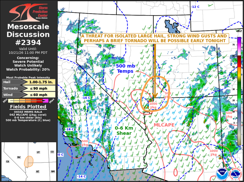
   Areas affected...Far Southeast Nevada...Far Southwest Utah...Far
   Northwest Arizona

   Concerning...Severe potential...Watch unlikely

   Valid 220453Z - 220600Z

   Probability of Watch Issuance...20 percent

   SUMMARY...An isolated threat for large hail, severe wind gusts and
   perhaps a brief tornado will be possible early tonight from far
   northeast Nevada into far southwest Utah.

   DISCUSSION...The latest surface analysis shows an axis of maximized
   low-level moisture from western Arizona extending
   north-northwestward into far southeastern Nevada, along which
   dewpoints are in the upper 50s and lower 60s F. The RAP has a
   localized maximum of instability in far southeast Nevada with MLCAPE
   around 1000 J/kg. Isolated thunderstorms have developed near the
   instability max over the last hour, likely in response to upslope
   flow. These storms are being supported by large-scale ascent
   associated with an approaching upper-level system. The latest VAD
   wind profile northeast of Las Vegas has 50 to 60 knots of flow in
   the mid-levels with substantial low-level shear. This environment
   should support an isolated severe threat. Supercells may be capable
   of producing isolated large hail, strong wind gusts and perhaps a
   brief tornado.

   ..Broyles/Smith.. 10/22/2026

   ...Please see www.spc.noaa.gov for graphic product...

   ATTN...WFO...SLC...VEF...

   LAT...LON   36311348 36201401 36191450 36291474 36561493 36961495
               37431480 37981447 38291398 38221331 37951302 37511283
               36651299 36311348

   MOST PROBABLE PEAK TORNADO INTENSITY...UP TO 90 MPH
   MOST PROBABLE PEAK WIND GUST...UP TO 60 MPH
   MOST PROBABLE PEAK HAIL SIZE...1.00-1.75 IN
|
|
|
Top/All Mesoscale Discussions/Forecast Products/Home |
|
Source link