

| Mesoscale Discussion 2387 | |
| < Previous MD | |

|
|
   Mesoscale Discussion 2387
   NWS Storm Prediction Center Norman OK
   0135 PM CDT Wed Oct 21 2026

   Areas affected...Parts of southern and central Arizona

   Concerning...Severe potential...Watch possible

   Valid 211835Z - 212100Z

   Probability of Watch Issuance...60 percent

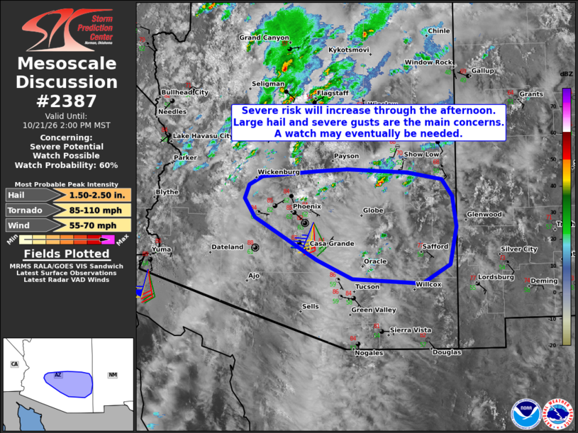
   SUMMARY...The severe risk will increase through the afternoon,
   especially between 20Z and 23Z. The primary concerns will be large
   hail and severe wind gusts. A watch may eventually be needed.

   DISCUSSION...The latest visible satellite imagery shows deepening
   boundary-layer cumulus evolving across parts of southern AZ --
   beneath a plume of mid/high-level clouds. Over the next few hours,
   continued differential heating and orographic circulations should
   promote scattered thunderstorm development in the 20Z-23Z time
   frame. The KEMX VWP is sampling an elongated hodograph (40-50 kt of
   0-6 km shear) and modest low-level hodograph curvature (albeit
   weaker low-level shear compared to areas farther north). This,
   combined with the destabilizing PBL, will support
   discrete/semi-discrete supercells and organized clusters. Given the
   expectation for separated updrafts, large to very large hail and
   locally severe gusts will be the primary concerns (though a tornado
   or two cannot be ruled out with any longer-lived supercells). While
   timing is somewhat uncertain, a watch may eventually be needed for
   parts of the area.

   ..Weinman/Mosier.. 10/21/2026

   ...Please see www.spc.noaa.gov for graphic product...

   ATTN...WFO...TWC...FGZ...PSR...

   LAT...LON   32340968 32401094 32691159 33351273 33641292 33841285
               33971261 34061157 34091105 34040993 33940931 33680912
               33210904 32630916 32340968

   MOST PROBABLE PEAK TORNADO INTENSITY...85-110 MPH
   MOST PROBABLE PEAK WIND GUST...55-70 MPH
   MOST PROBABLE PEAK HAIL SIZE...1.50-2.50 IN
|
|
|
Top/All Mesoscale Discussions/Forecast Products/Home |
|
Source link