

| Mesoscale Discussion 2377 | |
| < Previous MD | |

|
|
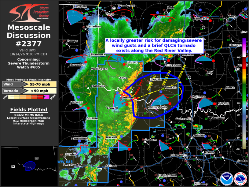
Mesoscale Discussion 2377 NWS Storm Prediction Center Norman OK 0835 PM CDT Wed Oct 14 2026 Areas affected...portions of the Red River Valley in southwestern Oklahoma/northwestern Texas Concerning...Severe Thunderstorm Watch 685... Valid 150135Z - 150230Z The severe weather threat for Severe Thunderstorm Watch 685 continues. SUMMARY...A locally greater risk for damaging/severe wind gusts and perhaps a brief tornado may exist over the next 1-2 hours along portions of the Red River Valley. DISCUSSION...Regional radar imagery depicts a well-defined QLCS with a prominent bowing segment and embedded mesovortex (as sampled by the KFDR radar) advancing northeastward along the Red River Valley across portions of southwestern Oklahoma/northwestern Texas. This bow is propagating eastward within a more stable low-level air mass located to the north of a remnant outflow boundary. Latest observations continue to depict backed surface flow within this air mass, however, with recent objective analysis also indicated the presence of clockwise curved low-level hodographs and 200-300 m2/s2 ESRH. This is likely to continue to support at least some risk for damaging/severe wind gusts and perhaps a brief QLCS tornado along portions of the Red River Valley in the near-term, with the greatest risk likely to exist poleward of the bow's apex. ..Chalmers.. 10/15/2026 ...Please see www.spc.noaa.gov for graphic product... ATTN...WFO...FWD...OUN... LAT...LON 34699870 34819833 34839792 34699756 34469741 34189746 33979764 33829793 33709829 33709872 33739887 33879891 34079891 34269903 34369919 34579888 34699870 MOST PROBABLE PEAK TORNADO INTENSITY...UP TO 90 MPH MOST PROBABLE PEAK WIND GUST...55-70 MPH |
|
|
Top/All Mesoscale Discussions/Forecast Products/Home |
|
Source link