

| Mesoscale Discussion 2376 | |
| < Previous MD | |

|
|
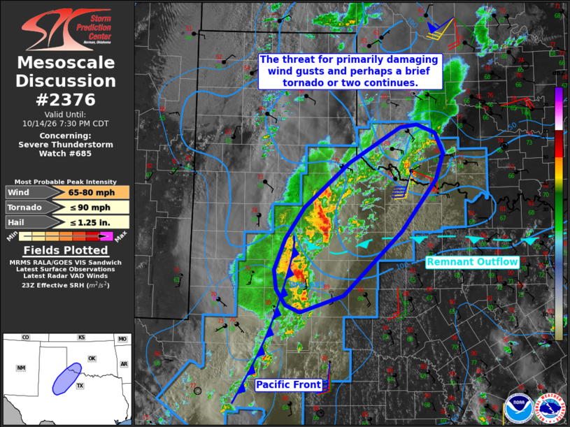
Mesoscale Discussion 2376 NWS Storm Prediction Center Norman OK 0601 PM CDT Wed Oct 14 2026 Areas affected...portions of West and Northwest Texas into southwestern Oklahoma Concerning...Severe Thunderstorm Watch 685... Valid 142301Z - 150030Z The severe weather threat for Severe Thunderstorm Watch 685 continues. SUMMARY...The threat for primarily damaging wind gusts and perhaps a brief tornado or two continues across Severe Thunderstorm Watch 685. DISCUSSION...Initially more cellular convection that formed along a north-south oriented Pacific cold front has largely trended toward a linear storm mode as of 2300 UTC, with two stronger clusters noted across West Texas. Several wind gusts measured/estimated in the 60-75 mph range have been noted with this activity over the past couple of hours. Expectation is for these clusters to continue to progress northeastward, which will gradually result in storms becoming elevated as they progress into greater low-level stability noted north of an east-west oriented remnant outflow boundary and becoming elevated. The primary threat with this activity will continue to be damaging/severe wind gusts. Backed surface winds are also noted across northwest Texas/southwest Oklahoma to the north of the outflow boundary and are contributing to clockwise-curved low-level hodographs that may support the potential for a brief tornado or two if storms can remain surface based. Recent CAM guidance (e.g., HRRR/RRFS runs) continues to suggest that the outflow boundary will eventually lift northward tonight, with greater low-level moisture returning to the Red River Valley vicinity and perhaps as far north as southern/central Oklahoma. Some increase in the threat for a brief tornado may manifest should this scenario occur. This remains uncertain, however, as this boundary has exhibited minimal northward motion over the past several hours. ..Chalmers.. 10/14/2026 ...Please see www.spc.noaa.gov for graphic product... ATTN...WFO...OUN...SJT...LUB...MAF... LAT...LON 32510148 32810152 33280131 33780096 34470013 35039918 35079886 34939853 34629837 34209852 33419915 32410023 32140103 32260131 32510148 MOST PROBABLE PEAK TORNADO INTENSITY...UP TO 90 MPH MOST PROBABLE PEAK WIND GUST...65-80 MPH MOST PROBABLE PEAK HAIL SIZE...UP TO 1.25 IN |
|
|
Top/All Mesoscale Discussions/Forecast Products/Home |
|
Source link