

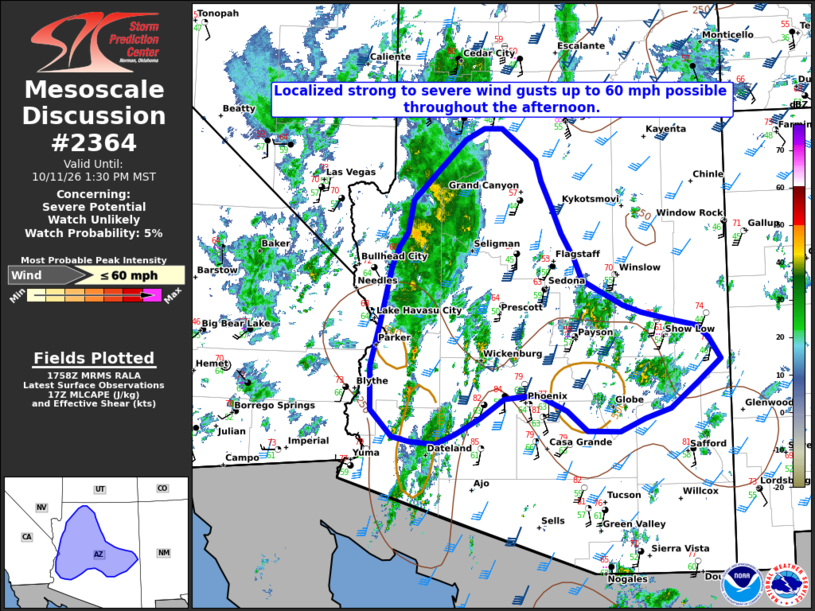
| Mesoscale Discussion 2364 | |
| < Previous MD | |

|
|
   Mesoscale Discussion 2364
   NWS Storm Prediction Center Norman OK
   0101 PM CDT Sun Oct 11 2026

   Areas affected...Portions of Central Arizona

   Concerning...Severe potential...Watch unlikely

   Valid 111801Z - 112030Z

   Probability of Watch Issuance...5 percent

   SUMMARY...Increasing thunderstorm coverage across central AZ is
   expected through this afternoon. A few localized strong to severe
   wind gusts up to 60 mph will be possible.

   DISCUSSION...Recent visible satellite and radar trends indicate an
   increase in deeper moist convection beginning to develop across
   portions of central AZ late this morning. Large scale ascent
   associated with the remnants of Rachel, approaching from the
   southwest, and continued destabilization are supporting this more
   robust, ongoing development along and east of the surface trough.
   Although only modest buoyancy is anticipated throughout the day,
   effective deep layer shear around 50 kt via a mid-level jet should
   support transient updraft organization. A bowing segment or two will
   be possible throughout this afternoon given the strong
   south-southwesterly low-level flow in place. In addition, merging
   thunderstorm clusters/enhanced cold pools could also produce a few
   strong to severe gusts. A thunderstorm watch is not expected at this
   time given the localized nature of the threat.

   ..Barnes/Smith.. 10/11/2026

   ...Please see www.spc.noaa.gov for graphic product...

   ATTN...WFO...TWC...FGZ...PSR...VEF...

   LAT...LON   33341436 33881437 34421422 34891412 35101406 35351395
               35541383 35931375 36281340 36681296 36821268 36821241
               36761234 36561207 36441191 36181183 35881168 35521152
               35221133 34951121 34821096 34631062 34551034 34460994
               34380954 34220935 33950917 33670951 33360993 33241030
               33071067 33091115 33341145 33541189 33491238 33251273
               33051310 32931340 32961377 33021404 33341436

   MOST PROBABLE PEAK WIND GUST...UP TO 60 MPH
|
|
|
Top/All Mesoscale Discussions/Forecast Products/Home |
|
Source link