

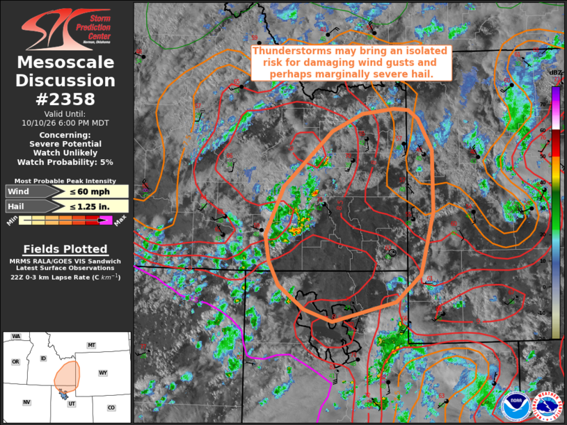
| Mesoscale Discussion 2358 | |
| < Previous MD | |

|
|
   Mesoscale Discussion 2358
   NWS Storm Prediction Center Norman OK
   0505 PM CDT Sat Oct 10 2026

   Areas affected...portions of southeastern Idaho...western
   Wyoming...and northern Utah

   Concerning...Severe potential...Watch unlikely

   Valid 102205Z - 110000Z

   Probability of Watch Issuance...5 percent

   SUMMARY...Developing thunderstorms may bring an isolated risk for
   damaging wind gusts and perhaps marginally severe hail.

   DISCUSSION...Recent observations indicate an uptick in lightning
   activity with ongoing convection coincident with the development of
   weak buoyancy (around 250-500 J/kg MLCAPE) across southeastern Idaho
   and northern Utah over the past hour. While available buoyancy is
   expected to remain limited, strong southwesterly flow aloft (30-40
   kts at ~3 km AGL per the MTX/SFX VWPs) downstream of an mid/upper
   trough centered over the Pacific Northwest is contributing to 30-45+
   kts of effective shear across the region. This will allow for
   convective organization into one or more linear clusters and perhaps
   marginal supercell structures. With steep low- and mid-level lapse
   rates (8-9+ C/km) noted via latest objective analysis and modified
   RAP forecast soundings, an isolated risk for damaging wind gusts may
   develop where stronger downdrafts can transport greater momentum to
   the surface. Marginally severe hail may also be possible with any
   transient supercell structure that can evolve owing to elongated
   hodographs and cool mid-level temperatures. The magnitude of the
   severe threat will generally be tempered by weak buoyancy and the
   relatively quick onset of nocturnal cooling within the next couple
   of hours, however, which will preclude the need for a watch.

   ..Chalmers/Gleason.. 10/10/2026

   ...Please see www.spc.noaa.gov for graphic product...

   ATTN...WFO...RIW...SLC...PIH...

   LAT...LON   43161334 43921244 44151188 44221127 44201101 44091083
               43661056 42791055 41931079 41561126 41301244 41471296
               41801344 42131361 42491369 43161334

   MOST PROBABLE PEAK WIND GUST...UP TO 60 MPH
   MOST PROBABLE PEAK HAIL SIZE...UP TO 1.25 IN
|
|
|
Top/All Mesoscale Discussions/Forecast Products/Home |
|
Source link