

| Mesoscale Discussion 2351 | |
| < Previous MD | |

|
|
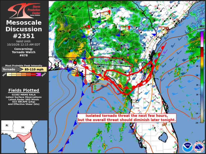
Mesoscale Discussion 2351 NWS Storm Prediction Center Norman OK 0940 PM CDT Fri Oct 09 2026 Areas affected...North Florida Concerning...Tornado Watch 678... Valid 100240Z - 100415Z The severe weather threat for Tornado Watch 678 continues. SUMMARY...An isolated tornado threat will persist through the early overnight hours in north Florida, well east of the weakening inner core of Isaias. DISCUSSION...Hurricane Isaias is weakening and will continue northward into southeast AL the next few hours. The hurricane is taking on more of a hybrid structure with time as a result of strong vertical shear and a notable intrusion of lower theta-e air west and south of the circulation center. Farther east, a surface warm front has been slow to advance inland across north FL and the FL Panhandle. Occasional cellular convection and a few thunderstorms persist in a confluence band from west of Tampa into north FL, and shallower convection is ongoing along the primary wind shift approaching the FL Big Bend. The lack of inland penetration of the more unstable warm sector has limited tornado threat this evening, with substantial improvements to low-level thermodynamic profiles unlikely tonight. There is still a small window of opportunity for supercells/tornadoes with convection spreading inland near the southeast corner of the watch, and a marginal supercell/brief tornado threat a bit east of the watch into northeast FL. However, the overall coverage and intensity of convection is expected to weaken slowly through the overnight hours. ..Thompson.. 10/10/2026 ...Please see www.spc.noaa.gov for graphic product... ATTN...WFO...TBW...JAX...TAE... LAT...LON 30598132 30158159 29918176 29678226 29158287 29238324 29988397 30138426 30388413 30408372 30128290 30328223 30858150 30598132 MOST PROBABLE PEAK TORNADO INTENSITY...85-110 MPH |
|
|
Top/All Mesoscale Discussions/Forecast Products/Home |
|
Source link