

| Mesoscale Discussion 2350 | |
| < Previous MD | |

|
|
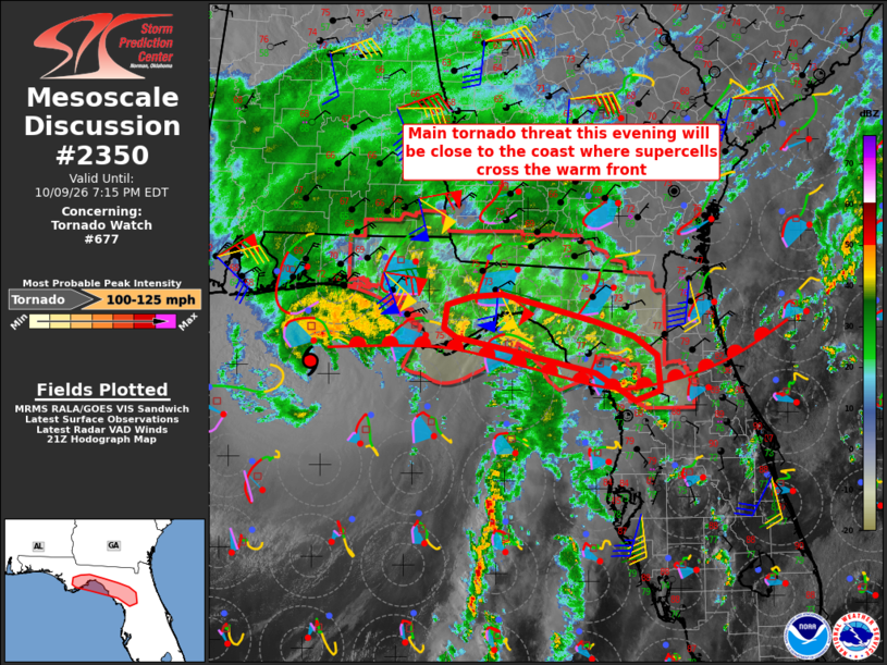
Mesoscale Discussion 2350 NWS Storm Prediction Center Norman OK 0448 PM CDT Fri Oct 09 2026 Areas affected...The Florida Panhandle Concerning...Tornado Watch 677... Valid 092148Z - 092315Z The severe weather threat for Tornado Watch 677 continues. SUMMARY...The main tornado threat this evening will be near the coast as supercells east of the hurricane core interact with a surface warm front. DISCUSSION...Hurricane Isaias will make landfall this evening along the western FL Panhandle coast (see latest NHC advisories for details). East of the inner hurricane core, broken bands of supercells will continue to spread northward into the FL Big Bend. As the hurricane moves northward, surface warm front will likewise make some northward progress, as evidenced by gradual increases in surface temperatures/dewpoints into the mid-upper 70s. These surface conditions will contribute to surface-based buoyancy near and a little inland from the coast over the next few hours. The VWP from KTLH shows a large, curved hodograph and estimated 0-1 km SRH has roughly doubled since 19z with largely streamwise vorticity in the low levels. The greatest tornado threat will be with the broken convective bands/supercells moving northward into the FL Big Bend and interacting with the zone of strongest low-level shear along the warm front. Tornado Watch 677 is scheduled to expire at 01z, but will be replaced with a new watch by 00-01z. ..Thompson.. 10/09/2026 ...Please see www.spc.noaa.gov for graphic product... ATTN...WFO...TBW...JAX...TAE... LAT...LON 29178211 29058244 29378299 29668420 29798490 29908506 30188503 30288468 30328426 30188368 29988298 29828247 29598214 29178211 MOST PROBABLE PEAK TORNADO INTENSITY...100-125 MPH |
|
|
Top/All Mesoscale Discussions/Forecast Products/Home |
|
Source link