

| Mesoscale Discussion 2347 | |
| < Previous MD | |

|
|
   Mesoscale Discussion 2347
   NWS Storm Prediction Center Norman OK
   0835 PM CDT Thu Oct 08 2026

   Areas affected...Southeast South Dakota into Iowa

   Concerning...Severe potential...Watch unlikely

   Valid 090135Z - 090300Z

   Probability of Watch Issuance...20 percent

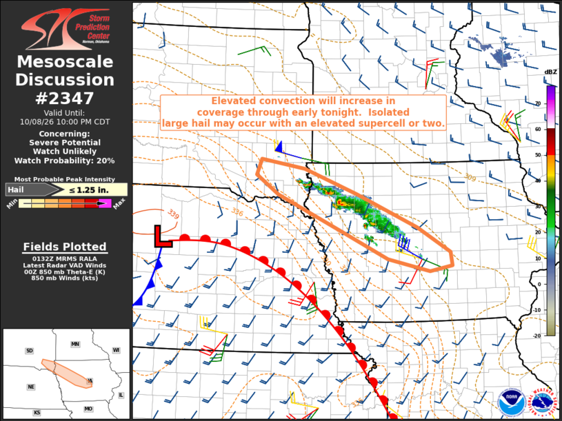
   SUMMARY...An elevated supercell or two may produce isolated large
   hail in the next few hours.  The marginal magnitude of the hail
   threat will likely preclude a watch.

   DISCUSSION...Elevated convection has been expanding in a
   northwest-southeast band from southeast SD into IA.  The convection
   appears to be rooted into the 850-700 mb layer in a zone of
   low-level warm advection on the northeast edge of an elevated mixed
   layer.  Isentropic upglide will increase through early tonight on
   the nose of a modestly strengthening low-level jet, which will
   support a continued increase in storm coverage through at least 04z.
   Upstream low-level moisture is sufficient for MUCAPE in excess of
   1000 J/kg and cloud-layer vertical shear is strong enough to support
   an elevated supercell or two the next few hours from southeast SD
   into IA.  Relatively steep midlevel lapse rates and the possibility
   of some supercell structures suggest that the strongest storms could
   produce isolated large hail near 1 inch diameter.  Current
   expectations are that the hail threat will remain too
   isolated/marginal to warrant a watch.

   ..Thompson/Gleason.. 10/09/2026

   ...Please see www.spc.noaa.gov for graphic product...

   ATTN...WFO...DMX...FSD...

   LAT...LON   41739455 42209562 42919727 43279783 43559770 43399662
               42929532 42309382 41849302 41609297 41509353 41739455

   MOST PROBABLE PEAK HAIL SIZE...UP TO 1.25 IN
|
|
|
Top/All Mesoscale Discussions/Forecast Products/Home |
|
Source link