

| Mesoscale Discussion 2343 | |
| < Previous MD Next MD > | |

|
|
   Mesoscale Discussion 2343
   NWS Storm Prediction Center Norman OK
   1121 PM CDT Wed Sep 30 2026

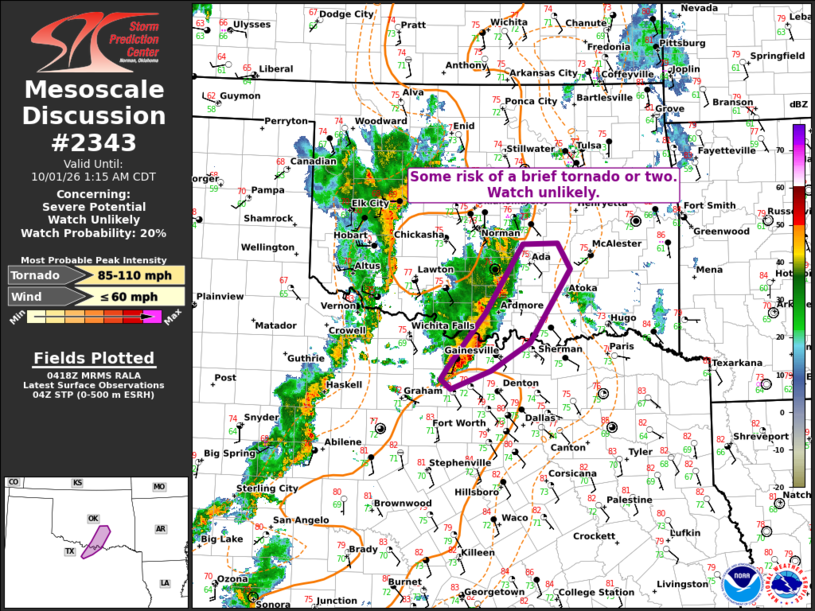
   Areas affected...North Texas...Southern Oklahoma

   Concerning...Severe potential...Watch unlikely

   Valid 010421Z - 010615Z

   Probability of Watch Issuance...20 percent

   SUMMARY...A cluster of thunderstorms over north-central TX will
   track north-northeastward into southern OK.  Increasing shear
   profiles could lead to a brief tornado or two.  The overall threat
   appears limited, and a watch is not currently expected.

   DISCUSSION...A cluster of thunderstorms is currently affecting
   Wise/Montague counties of north-central TX.  The VAD profile at FWS
   has shown recent acceleration of low-level winds, with 1km AGL winds
   over 40 knots and 0-1km SRH over 300 m2/s2.  Recent radar trends
   have shown a few weak low/mid-level circulations in the cluster of
   storms, evidence of the enhanced shear profiles.  Given the influx
   of moist and marginally unstable air (dewpoints in the low 70s and
   MLCAPE ~800 J/kg), there is some potential for a brief tornado or
   two or locally damaging winds in this cluster for the next couple of
   hours.  Given relatively low confidence and the small area of
   concern, a watch is not currently anticipated.

   ..Hart.. 10/01/2026

   ...Please see www.spc.noaa.gov for graphic product...

   ATTN...WFO...TSA...FWD...OUN...

   LAT...LON   33489792 34169735 35029680 35029627 34709608 33799668
               33459727 33229786 33349801 33489792

   MOST PROBABLE PEAK TORNADO INTENSITY...85-110 MPH
   MOST PROBABLE PEAK WIND GUST...UP TO 60 MPH
|
|
|
Top/All Mesoscale Discussions/Forecast Products/Home |
|
Source link