

| Mesoscale Discussion 2327 | |
| < Previous MD | |

|
|
   Mesoscale Discussion 2327
   NWS Storm Prediction Center Norman OK
   0136 PM CDT Thu Sep 24 2026

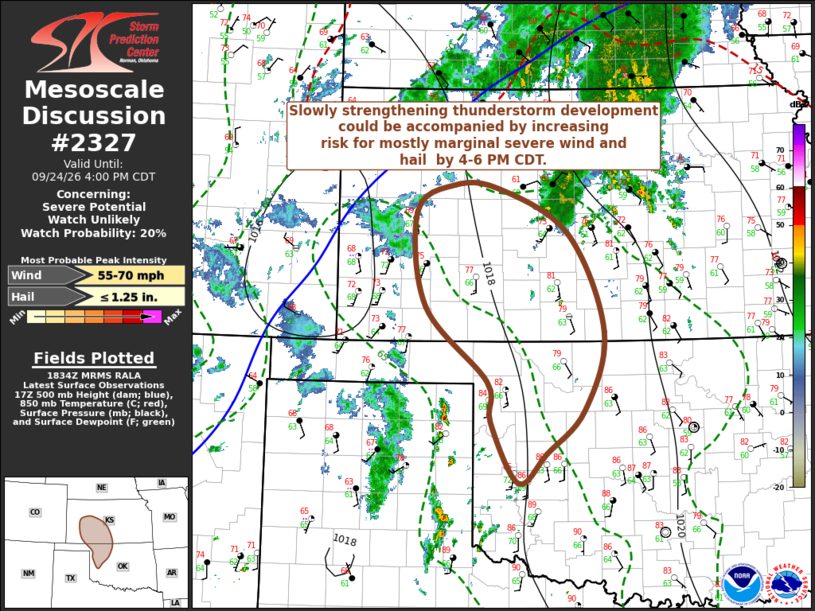
   Areas affected...parts of western Kansas and northwestern Oklahoma

   Concerning...Severe potential...Watch unlikely

   Valid 241836Z - 242100Z

   Probability of Watch Issuance...20 percent

   SUMMARY...Increasing thunderstorm development may slowly strengthen
   and become better organized while spreading northeastward through
   4-6 PM CDT.  The associated risk for severe wind and hail appears
   mostly marginal in nature and it still appears unlikely that a
   severe weather watch will be needed.  However, trends will continue
   to be monitored.

   DISCUSSION...A couple of weak/low-amplitude short wave perturbations
   are progressing through modest southwesterly flow across the Texas
   South Plains through central Great Plains early this afternoon.
   This is occurring on the western periphery of fairly prominent
   mid-level ridging centered (in the 700-500 mb layer) across the
   southeastern Great Plains.

   In the wake of the lead perturbation, and in advance of the trailing
   one, latest objective analysis indicates that a corridor of stronger
   boundary-layer destabilization is underway near the western
   Oklahoma/Texas border vicinity through southwestern Kansas.  This is
   occurring in response to low-level moistening and insolation along
   the weaker southwestern periphery of expansive cool surface ridging
   (centered over Quebec), and forecast to slowly shift
   north-northeastward through 21-23Z.  As it does, Rapid Refresh
   output suggests that mixed-layer CAPE may continue increase through
   the 1000-2000 J/kg range, and the environment may gradually become
   more conducive to organizing thunderstorm development in the
   presence of modest shear.

   Beneath mid-level flow on the order of 30 kt, this could perhaps
   include evolving supercell structures and an upscale growing
   cluster.  However, rather modest lower/mid-tropospheric lapse rates
   and temperature/dew point spreads seem likely to result in mostly
   marginal severe wind and hail potential.

   ..Kerr/Mosier.. 09/24/2026

   ...Please see www.spc.noaa.gov for graphic product...

   ATTN...WFO...ICT...OUN...DDC...GLD...AMA...

   LAT...LON   36179836 35669891 35319933 36039975 36529980 37410072
               38530086 38860030 38829962 38279859 37119805 36179836

   MOST PROBABLE PEAK WIND GUST...55-70 MPH
   MOST PROBABLE PEAK HAIL SIZE...UP TO 1.25 IN
|
|
|
Top/All Mesoscale Discussions/Forecast Products/Home |
|
Source link