

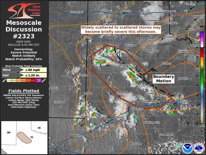
| Mesoscale Discussion 2323 | |
| < Previous MD | |

|
|
   Mesoscale Discussion 2323
   NWS Storm Prediction Center Norman OK
   0238 PM CDT Mon Sep 21 2026

   Areas affected...Texas South Plains into Permian Basin

   Concerning...Severe potential...Watch unlikely

   Valid 211938Z - 212145Z

   Probability of Watch Issuance...20 percent

   SUMMARY...Widely scattered to potentially scattered storms may
   become briefly severe and be capable of large hail and marginally
   severe wind gusts. Weak shear and modest thermodynamics should
   preclude watch issuance this afternoon.

   DISCUSSION...Widely scattered storms have developed near the
   intersection of a weak surface trough and cold front. The cold front
   has been moving to southwest around 15 kt. The strongest storms will
   likely occur within the surface trough. Activity along the cold
   front will have a tendency to be undercut and may not be more than
   briefly severe. Mid-level lapse rates inferred from the 18Z observed
   AMA/MAF soundings would suggest large hail will be possible along
   with marginally severe wind gusts. However, somewhat cool
   temperatures and weak shear (noted on the KLBB VAD) will otherwise
   limit the severe potential.

   ..Wendt/Mosier.. 09/21/2026

   ...Please see www.spc.noaa.gov for graphic product...

   ATTN...WFO...SJT...LUB...MAF...

   LAT...LON   32640183 33460284 33900288 34230230 34060163 33340079
               32800005 32609996 32350035 32290102 32640183

   MOST PROBABLE PEAK WIND GUST...UP TO 60 MPH
   MOST PROBABLE PEAK HAIL SIZE...UP TO 1.25 IN
|
|
|
Top/All Mesoscale Discussions/Forecast Products/Home |
|
Source link