

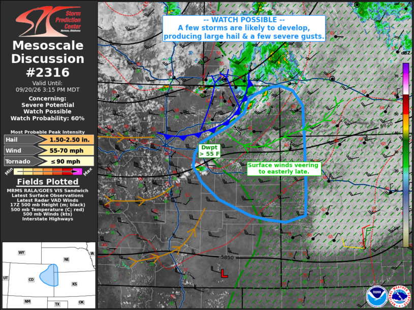
| Mesoscale Discussion 2316 | |
| < Previous MD | |

|
|
   Mesoscale Discussion 2316
   NWS Storm Prediction Center Norman OK
   0149 PM CDT Sun Sep 20 2026

   Areas affected...northeast/eastern Colorado...far western Kansas and
   southwest Nebraska

   Concerning...Severe potential...Watch possible

   Valid 201849Z - 202115Z

   Probability of Watch Issuance...60 percent

   SUMMARY...At least isolated storms are likely to develop over
   northeast Colorado, with large hail probable. A few severe gusts
   could occur by early evening.

   DISCUSSION...A prominent vorticity max aloft is moving across WY,
   with southern lobe and cooling aloft spreading across northern CO.
   Visible imagery shows towering CU and initial convection over the
   Palmer Divide, and over far northeast CO south of a wind shift
   related to ongoing weak thunderstorms.

   Continued heating along with a gradual veering of surface winds will
   lead to further destabilization. Given cool temperatures
   aloft/steepening lapse rates, mid 50s F dewpoints and effective
   deep-layer shear over 40 kt, a supercell or two may occur. Max hail
   size over 2.00" may be possible as cells generally track
   southeastward toward western KS by early evening. Left splitting
   cells may also produce hail into southwest NE. Damaging wind gusts
   also appear possible if more of a cluster or aggregating outflows
   develop.

   ..Jewell/Mosier.. 09/20/2026

   ...Please see www.spc.noaa.gov for graphic product...

   ATTN...WFO...LBF...GLD...PUB...BOU...

   LAT...LON   40220334 40460298 40730285 40840268 40980228 41000202
               40900172 40610145 39830141 38920139 38430141 38290190
               38350236 38430280 38750360 39090405 39400426 39640424
               39860407 40220334

   MOST PROBABLE PEAK TORNADO INTENSITY...UP TO 90 MPH
   MOST PROBABLE PEAK WIND GUST...55-70 MPH
   MOST PROBABLE PEAK HAIL SIZE...1.50-2.50 IN
|
|
|
Top/All Mesoscale Discussions/Forecast Products/Home |
|
Source link