

| Mesoscale Discussion 2315 | |
| < Previous MD | |

|
|
   Mesoscale Discussion 2315
   NWS Storm Prediction Center Norman OK
   0139 PM CDT Sun Sep 20 2026

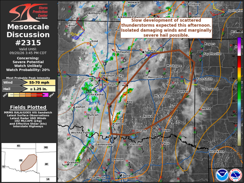
   Areas affected...South-central into east-central Oklahoma

   Concerning...Severe potential...Watch unlikely

   Valid 201839Z - 202045Z

   Probability of Watch Issuance...20 percent

   SUMMARY...Damaging winds and isolated, marginally severe hail may
   occur with the strongest storms this afternoon. The spatial extent
   of severe potential may remain isolated. The need for a watch is
   uncertain and trends will continue to be monitored through the
   afternoon.

   DISCUSSION...Convective activity has been increasing within the
   surface trough in central/eastern Oklahoma. A recent TAMDAR sounding
   from TUL suggest MLCIN remains owing to some cloud cover; however,
   MLCIN should slowly weaken with time as has been noted within the
   Ouchita Mountains on visible satellite. The KINX VAD shows a
   relatively disorganized wind profile. More favorable wind profiles
   are likely to remain displaced from the better thermodynamic
   environment. Even so, around 25-30 kt of effective shear will still
   be in place due to the weak mid-level perturbation in to the
   immediate west. Moderately steep low-level lapse rates and a
   well-mixed boundary layer will mean damaging wind potential with the
   strongest storms. Given the observed 7 C/km mid-level lapse rates,
   isolated marginally severe hail may also  occur. While widely
   scattered to scattered coverage will eventually evolved, the overall
   severity of this activity is not certain given the expected
   disorganized modes.

   ..Wendt/Mosier.. 09/20/2026

   ...Please see www.spc.noaa.gov for graphic product...

   ATTN...WFO...TSA...FWD...OUN...

   LAT...LON   33969717 34709726 36139583 36239494 35899443 35119460
               34469530 34069612 33939663 33969717

   MOST PROBABLE PEAK WIND GUST...55-70 MPH
   MOST PROBABLE PEAK HAIL SIZE...UP TO 1.25 IN
|
|
|
Top/All Mesoscale Discussions/Forecast Products/Home |
|
Source link