

| Mesoscale Discussion 2313 | |
| < Previous MD | |

|
|
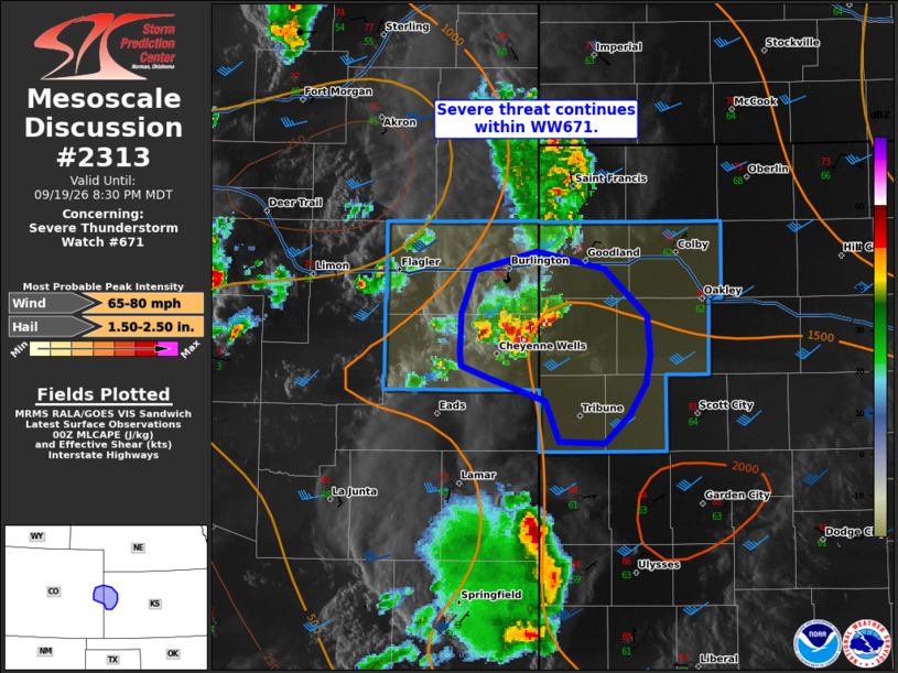
Mesoscale Discussion 2313 NWS Storm Prediction Center Norman OK 0729 PM CDT Sat Sep 19 2026 Areas affected...eastern Colorado into western Kansas Concerning...Severe Thunderstorm Watch 671... Valid 200029Z - 200230Z The severe weather threat for Severe Thunderstorm Watch 671 continues. SUMMARY...Severe threat continues within WW671. DISCUSSION...Supercells continue within WW671, producing 1.75-2 inch hail across eastern Colorado. Several storm interactions have occurred, with a hybrid supercell/multicell cluster and outflow boundary moving southeastward. Storms are steadily moving into a more favorably sheared and moist/unstable air mass. The threat for large hail will continue in the short term, with potential for hail up to 2 inches. Observational trends and CAM guidance would suggest that storms may eventually cluster along outflow with an increase in damaging wind potential into the evening. ..Thornton.. 09/20/2026 ...Please see www.spc.noaa.gov for graphic product... ATTN...WFO...GLD...PUB... LAT...LON 39390205 39290251 39040260 38820262 38740261 38680241 38550200 38310190 38310156 38470138 38650126 38810123 39020125 39300156 39390205 MOST PROBABLE PEAK WIND GUST...65-80 MPH MOST PROBABLE PEAK HAIL SIZE...1.50-2.50 IN |
|
|
Top/All Mesoscale Discussions/Forecast Products/Home |
|
Source link