

| Mesoscale Discussion 2298 | |
| < Previous MD | |
|
|
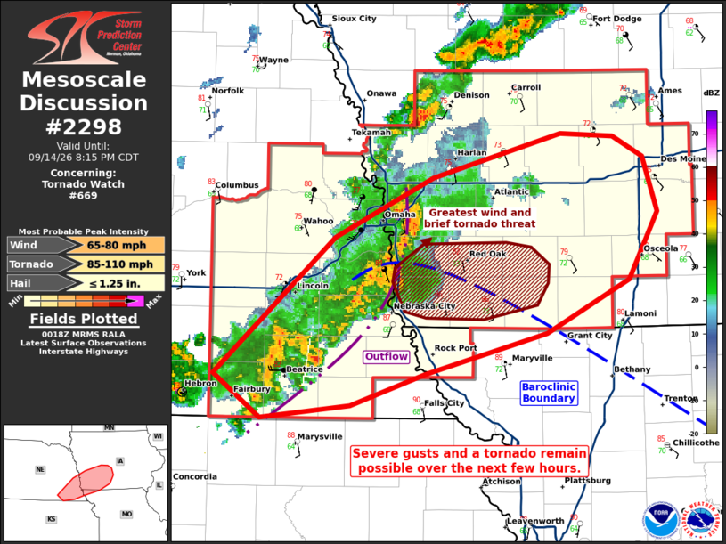
Mesoscale Discussion 2298 NWS Storm Prediction Center Norman OK 0720 PM CDT Mon Sep 14 2026 Areas affected...portions of southeastern Nebraska into central Iowa Concerning...Tornado Watch 669... Valid 150020Z - 150115Z The severe weather threat for Tornado Watch 669 continues. SUMMARY...A few severe gusts and a tornado remain possible over the next few hours. The best chance for any severe will be with a thunderstorm cluster traversing a differential heating boundary over the next 1-2 hours. DISCUSSION...A loosely organized line of thunderstorms is crossing the NE/IA border with a history of severe gusts. These storms will continue to propagate eastward into a highly sheared, destabilizing airmass, accompanied by a severe gust threat. The best chance for severe gusts, including any additional 75+ mph gusts or a brief tornado will be with the embedded thunderstorm cluster that is currently traversing a differential heating boundary. ..Squitieri.. 09/15/2026 ...Please see www.spc.noaa.gov for graphic product... ATTN...WFO...DMX...EAX...OAX... LAT...LON 40279733 41159633 41529550 41819444 41789399 41669374 41309363 40889387 40539456 40279558 40079620 40009694 40279733 MOST PROBABLE PEAK TORNADO INTENSITY...85-110 MPH MOST PROBABLE PEAK WIND GUST...65-80 MPH MOST PROBABLE PEAK HAIL SIZE...UP TO 1.25 IN |
|
|
Top/All Mesoscale Discussions/Forecast Products/Home |
|
Source link