

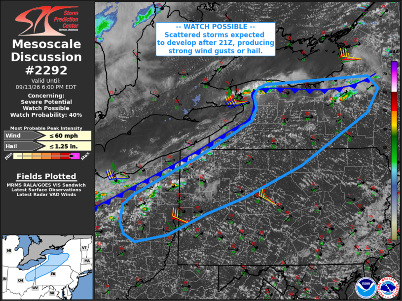
| Mesoscale Discussion 2292 | |
| < Previous MD | |

|
|
   Mesoscale Discussion 2292
   NWS Storm Prediction Center Norman OK
   0259 PM CDT Sun Sep 13 2026

   Areas affected...northeast Ohio...northwest Pennsylvania...western
   New York

   Concerning...Severe potential...Watch possible

   Valid 131959Z - 132200Z

   Probability of Watch Issuance...40 percent

   SUMMARY...Storms will increase in coverage and intensity over the
   new few hours along the cold front from northeast Ohio into parts of
   western/central New York. Trends will continue to be monitored for
   watch potential.

   DISCUSSION...Height falls with the upper trough are now spreading
   across MI and approaching the Lower Great Lakes. Gradual
   destabilization is underway ahead of the cold front, which extends
   roughly from western NY into OH. Deepening CU and convective showers
   are also evident over north-central OH and into northwest PA, and
   farther northeast along the lake breezes into NY.

   Given continued heating, lift along the front and at least some
   cooling aloft, storm coverage and intensity should increase along
   the effective front over the next several hours. The 18Z PIT
   sounding shows 40 kt midlevel winds along with stronger speeds in
   the upper levels, although speeds below 700 mb are generally weak.
   However, overall wind profiles may increase later today, supporting
   at least some threat of storm organization.

   Effective deep-layer shear around 40-45 kt may support cellular
   storm mode at times, along with smaller-scale bowing structures/line
   segments as well. Marginal hail and locally strong to damaging gusts
   may occur through early evening.

   ..Jewell/Guyer.. 09/13/2026

   ...Please see www.spc.noaa.gov for graphic product...

   ATTN...WFO...BGM...BUF...CTP...PBZ...CLE...

   LAT...LON   40717982 40308081 40158164 40308193 40548204 40888198
               41078170 41818010 42307912 42577863 42827850 43057856
               43217845 43277826 43417553 43167525 42697556 41687732
               41057881 40717982

   MOST PROBABLE PEAK WIND GUST...UP TO 60 MPH
   MOST PROBABLE PEAK HAIL SIZE...UP TO 1.25 IN
|
|
|
Top/All Mesoscale Discussions/Forecast Products/Home |
|
Source link