

| Mesoscale Discussion 2291 | |
| < Previous MD | |

|
|
   Mesoscale Discussion 2291
   NWS Storm Prediction Center Norman OK
   0736 PM CDT Sat Sep 12 2026

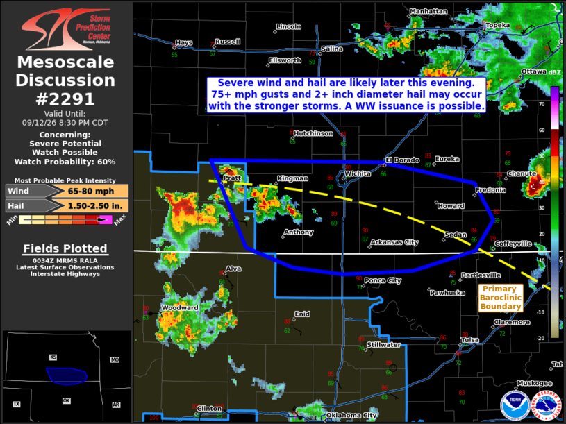
   Areas affected...portions of southern Kansas into far northern
   Oklahoma

   Concerning...Severe potential...Watch possible

   Valid 130036Z - 130130Z

   Probability of Watch Issuance...60 percent

   SUMMARY...The risk for severe wind and hail will increase over the
   next few hours as storms increase in coverage and traverse a surface
   boundary over southern KS. A few significant severe wind/hail events
   may occur with the strongest storms. A Severe Thunderstorm Watch
   will be considered in the short term.

   DISCUSSION...Thunderstorms are rapidly increasing in coverage and
   intensity along a surface baroclinic boundary. These storms are
   expected to propagate eastward along the boundary over the next
   several hours, where ample buoyancy and vertical wind shear are
   present (i.e. 3000 J/kg MLCAPE and 50 kts of effective bulk shear,
   respectively). Supercells and multicells should be the main storm
   mode, at least initially. However, if storms can merge, then a
   cold-pool-driven MCS may manifest. Given 8+ C/km mid-level lapse
   rates present (per the 00Z DDC observed sounding), supercell
   structures may produce 2+ inch diameter hail, with 75+ mph gusts
   possible with multicell structures or especially an MCS.

   ..Squitieri/Smith.. 09/13/2026

   ...Please see www.spc.noaa.gov for graphic product...

   ATTN...WFO...TSA...ICT...OUN...DDC...

   LAT...LON   37859887 37849689 37649582 37309561 37029581 36849654
               36809733 36869791 37059845 37859887

   MOST PROBABLE PEAK WIND GUST...65-80 MPH
   MOST PROBABLE PEAK HAIL SIZE...1.50-2.50 IN
|
|
|
Top/All Mesoscale Discussions/Forecast Products/Home |
|
Source link