

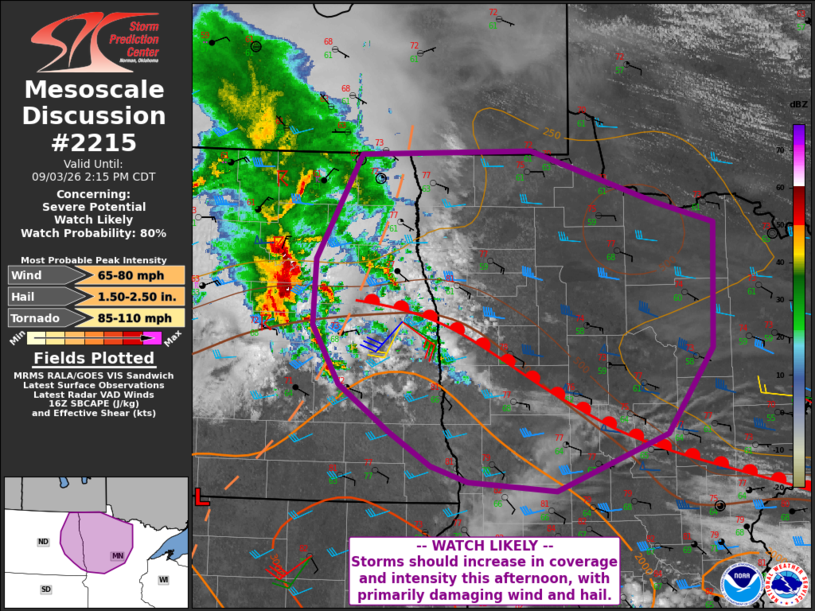
| Mesoscale Discussion 2215 | |
| < Previous MD | |

|
|
   Mesoscale Discussion 2215
   NWS Storm Prediction Center Norman OK
   1146 AM CDT Thu Sep 03 2026

   Areas affected...eastern North Dakota into northern Minnesota

   Concerning...Severe potential...Watch likely

   Valid 031646Z - 031915Z

   Probability of Watch Issuance...80 percent

   SUMMARY...Storms are likely to increase in coverage and intensity
   this afternoon as they develop out of North Dakota and into
   Minnesota. Damaging winds and large hail appear most likely.

   DISCUSSION...A substantial north-south oriented line of
   thunderstorms has maintained intensity last few hours, with periodic
   severe hail cores and possible strong winds. These storms are near
   an inverted trough which links with a surface low near the ND/SD
   border. This system is also approaching a warm front over
   east-central ND, with mid to upper 60s F dewpoints south of the
   boundary.

   Visible imagery shows strong heating over southeast ND into northern
   MN, with a cloud field near the warm front and immediately
   east/southeast of the storms. As heating continues, the warm front
   is forecast to lift, and as this occurs, new development is
   anticipated along southern parts of the line of storms.
   Southeastward propagation may then occur, with a corridor of
   damaging winds likely expanding into MN.

   Steep lapse rates aloft will also favor hail production, with
   possible wind-driven hail later today. A tornado cannot be ruled
   later today and into the evening where the line of storms intersects
   the warm front/zone of enhanced low-level shear.

   ..Jewell/Guyer.. 09/03/2026

   ...Please see www.spc.noaa.gov for graphic product...

   ATTN...WFO...DLH...MPX...FGF...

   LAT...LON   46039531 46129645 46269693 46569747 46969813 47499848
               48079845 48999786 49039564 48569400 48399325 47299329
               46549389 46039531

   MOST PROBABLE PEAK TORNADO INTENSITY...85-110 MPH
   MOST PROBABLE PEAK WIND GUST...65-80 MPH
   MOST PROBABLE PEAK HAIL SIZE...1.50-2.50 IN
|
|
|
Top/All Mesoscale Discussions/Forecast Products/Home |
|
Source link