

| Mesoscale Discussion 2160 | |
| < Previous MD | |
|
|
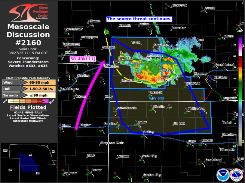
Mesoscale Discussion 2160 NWS Storm Prediction Center Norman OK 0946 PM CDT Thu Aug 27 2026 Areas affected...southern Nebraska into northwest Kansas Concerning...Severe Thunderstorm Watch 633...635... Valid 280246Z - 280415Z The severe weather threat for Severe Thunderstorm Watch 633, 635 continues. SUMMARY...A bowing complex of thunderstorms will continue to pose a risk for severe wind gusts and some hail this evening. It is unclear how long the complex will persist, but the environment is likely to remain favorable for the next few hours. DISCUSSION...As of 0245 UTC, central Plains radar imagery showed a well-organized bowing complex moving southward across NE and approaching the KS border. This complex has a history of severe wind gusts and is maintaining overall intensity. The environment downstream remains favorable for severe gusts with large buoyancy and 40+ kt of northwesterly effective shear. This suggests the complex may remain capable of severe gusts for several more hours. Thus, the severe risk continues across WW633 and 635. More supercellular activity has also matured along the western flank of the complex in the last hour or two. As the low-level jet (30-40 kt) is forecast to increase tonight, additional upshear development is possible with some risk for large hail of 1-2 inches in the most intense cores given 2500 J/kg of MLCAPE and increasingly strong veering wind profiles with height. ..Lyons.. 08/28/2026 ...Please see www.spc.noaa.gov for graphic product... ATTN...WFO...GID...LBF...DDC...GLD... LAT...LON 41690196 41380126 41290013 41149968 39269857 39110008 39170122 39430158 40530197 41690196 MOST PROBABLE PEAK TORNADO INTENSITY...UP TO 90 MPH MOST PROBABLE PEAK WIND GUST...65-80 MPH MOST PROBABLE PEAK HAIL SIZE...1.50-2.50 IN |
|
|
Top/All Mesoscale Discussions/Forecast Products/Home |
|
Source link