

| Mesoscale Discussion 2158 | |
| < Previous MD | |
|
|
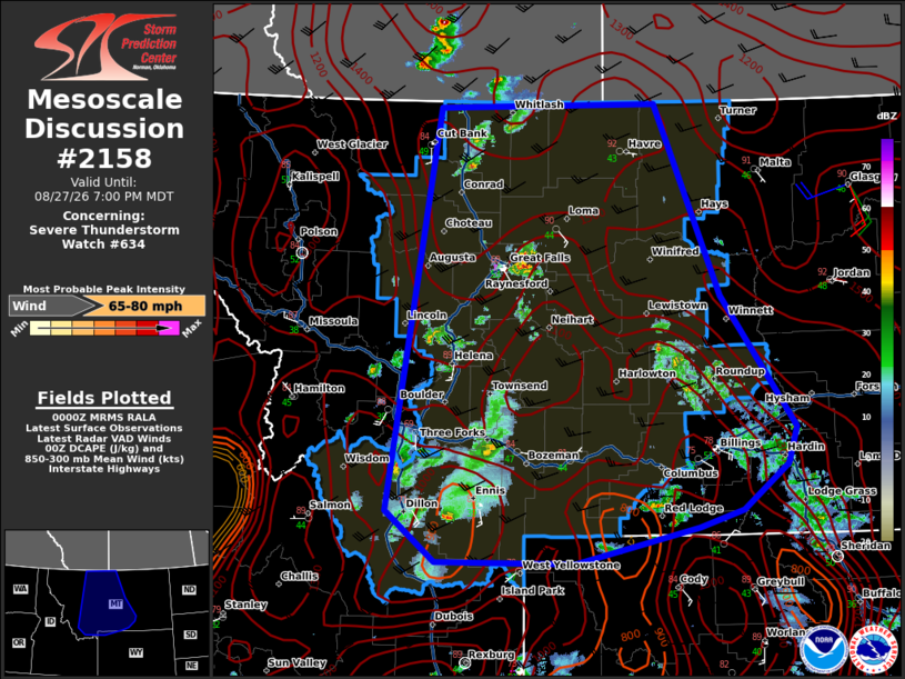
Mesoscale Discussion 2158 NWS Storm Prediction Center Norman OK 0703 PM CDT Thu Aug 27 2026 Areas affected...central Montana Concerning...Severe Thunderstorm Watch 634... Valid 280003Z - 280100Z The severe weather threat for Severe Thunderstorm Watch 634 continues. SUMMARY...High-based shower and thunderstorm activity will remain capable of strong to severe gusts this evening. DISCUSSION...Across WW634, widely scattered showers and thunderstorms were ongoing this evening over much of central MT. The more robust of these clusters (near the Great Falls vicinity) have produced occasional measured severe gusts over the last 90 min. The overall environment remains very supportive of strong downdrafts across much of central MT owing to steep low-level lapse rates (8-9 C/km) and high cloud bases above 3 km. While instability remains modest (500-1000 J/kg of MLCAPE) surface temperatures in the upper 80s and low 90s should be sufficient to maintain the ongoing storms as they move east/northeast this evening. Severe gust potential appears maximized near the aforementioned established clusters of storms, but any coherent downdraft will likely be capable of strong to severe gusts this evening. ..Lyons.. 08/28/2026 ...Please see www.spc.noaa.gov for graphic product... ATTN...WFO...BYZ...GGW...RIW...TFX...PIH...MSO... LAT...LON 47200842 45990743 45640755 45220816 45060874 44731037 44751222 45221288 48941221 48970929 47200842 MOST PROBABLE PEAK WIND GUST...65-80 MPH |
|
|
Top/All Mesoscale Discussions/Forecast Products/Home |
|
Source link