

| Mesoscale Discussion 2148 | |
| < Previous MD Next MD > | |
|
|
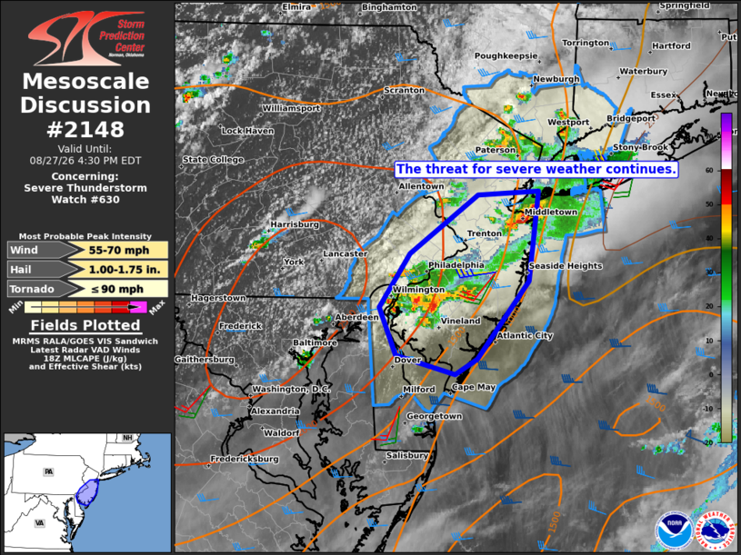
Mesoscale Discussion 2148 NWS Storm Prediction Center Norman OK 0129 PM CDT Thu Aug 27 2026 Areas affected...eastern Pennsylvania...New Jersey...northern and central Delaware...southeast New York...and southwest Connecticut Concerning...Severe Thunderstorm Watch 630... Valid 271829Z - 272030Z The severe weather threat for Severe Thunderstorm Watch 630 continues. SUMMARY...The threat for severe weather continues across the watch area with the greatest threat in New Jersey. DISCUSSION...Volumetric radar data shows intense thunderstorms ongoing over northern and southwestern portions of NJ as of 1820Z. Some supercell characteristics have been observed with these storms, with wind damage reported with the southern cluster of storms. The inflow air mass to these storms over eastern NJ is warm and quite moist with MLCAPE of 1000-2000 J/kg. Additionally, the current KDIX VWP is sampling a vertically veering wind profile with around 35 kt of deep-layer shear, which will continue to promote embedded supercell structures given the moist, unstable environment. In the near term, the greatest tornado risk appears to exist with the storm over Monmouth County, NJ with the storms over southern NJ being more outflow dominant. Otherwise, the primary hazard appears to be damaging wind gusts with the ongoing activity. ..Mead.. 08/27/2026 ...Please see www.spc.noaa.gov for graphic product... ATTN...WFO...OKX...PHI... LAT...LON 39647567 40097533 40587459 40627394 39867405 39217460 39087484 39247549 39647567 MOST PROBABLE PEAK TORNADO INTENSITY...UP TO 90 MPH MOST PROBABLE PEAK WIND GUST...55-70 MPH MOST PROBABLE PEAK HAIL SIZE...1.00-1.75 IN |
|
|
Top/All Mesoscale Discussions/Forecast Products/Home |
|
Source link