

| Mesoscale Discussion 2136 | |
| < Previous MD | |

|
|
   Mesoscale Discussion 2136
   NWS Storm Prediction Center Norman OK
   1202 PM CDT Wed Aug 26 2026

   Areas affected...southern middle Tennessee...eastern
   Mississippi...western and central parts of Alabama

   Concerning...Severe potential...Watch unlikely

   Valid 261702Z - 261930Z

   Probability of Watch Issuance...20 percent

   SUMMARY...The risk for isolated occurrences of damaging winds is
   expected to increase by mid afternoon. A watch appears unlikely due
   to the limited areal coverage of the threat.

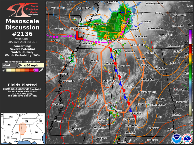
   DISCUSSION...A sub-severe MCS is ongoing across portions of western
   and middle TN as of late morning with a southeastward motion of
   25-30 kt. Visible satellite imagery indicates additional deepening
   cumulus and incipient thunderstorm development over portions of
   eastern MS and western AL, in the vicinity of a weak
   quasi-stationary boundary analyzed in that area. The air mass across
   the discussion area is characterized by temperatures in the mid 80s
   to lower 90s with dewpoints in the upper 60s to mid 70s, yielding
   MLCAPE up to 1500-2500 J/kg, per latest objective analysis.

   Latest model guidance indicates a gradual increase in storm coverage
   this afternoon along the cold pool/gust front associated with the
   MCS as well as in the vicinity of the stationary front mentioned
   above. Weak mid-level lapse rates and vertical shear are expected to
   limit the potential for an organized severe weather threat. However,
   steepening low-level lapse rates and the presence of a relatively
   moist environment (PW of 1.8-2 inches) suggest the potential for
   locally intense wet microbursts capable of damaging wind gusts.

   ..Mead/Mosier.. 08/26/2026

   ...Please see www.spc.noaa.gov for graphic product...

   ATTN...WFO...OHX...BMX...HUN...MOB...MEG...JAN...

   LAT...LON   32208861 33338889 34858895 35328836 35468783 35398704
               34328656 33108675 32238751 32088761 32208861

   MOST PROBABLE PEAK WIND GUST...UP TO 60 MPH
|
|
|
Top/All Mesoscale Discussions/Forecast Products/Home |
|
Source link