

| Mesoscale Discussion 2133 | |
| < Previous MD Next MD > | |
|
|
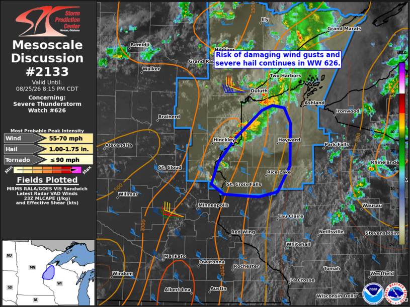
Mesoscale Discussion 2133 NWS Storm Prediction Center Norman OK 0648 PM CDT Tue Aug 25 2026 Areas affected...Parts of northwestern Wisconsin Concerning...Severe Thunderstorm Watch 626... Valid 252348Z - 260115Z The severe weather threat for Severe Thunderstorm Watch 626 continues. SUMMARY...The risk of damaging wind gusts and severe hail will generally remain focused across parts of northwestern Wisconsin for the next couple hours -- within Severe Thunderstorm Watch 626. DISCUSSION...A NNE/SSW-oriented surface front/wind shift moving eastward across far northwestern WI remains the focus for ongoing convective clusters, with transient/embedded rotation. Around 30-40 kt of west-northwesterly deep-layer shear (per DLH VWP data) oriented perpendicular to the front and a narrow corridor of weak-moderate pre-convective buoyancy should continue to support this activity for the next couple hours. Given the clustered mode with some deeper/separated cores, the primary concern will continue to be damaging wind gusts and severe hail. While unlikely, the transient embedded rotation and ongoing cell interactions could still support a brief/weak tornado risk, aided by some increase in a southerly low-level jet over the next couple hours. With time and eastward extent, these storms will move into an increasingly stable air mass in north-central WI (evident in surface observations and visible satellite imagery). Therefore, a downstream watch is unlikely. ..Weinman.. 08/25/2026 ...Please see www.spc.noaa.gov for graphic product... ATTN...WFO...DLH...MPX... LAT...LON 46099243 46539183 46619158 46569131 46329118 45669119 45249147 45169189 45219268 45379295 45709281 46099243 MOST PROBABLE PEAK TORNADO INTENSITY...UP TO 90 MPH MOST PROBABLE PEAK WIND GUST...55-70 MPH MOST PROBABLE PEAK HAIL SIZE...1.00-1.75 IN |
|
|
Top/All Mesoscale Discussions/Forecast Products/Home |
|
Source link