

| Mesoscale Discussion 2116 | |
| < Previous MD Next MD > | |
|
|
   Mesoscale Discussion 2116
   NWS Storm Prediction Center Norman OK
   0236 PM CDT Mon Aug 24 2026

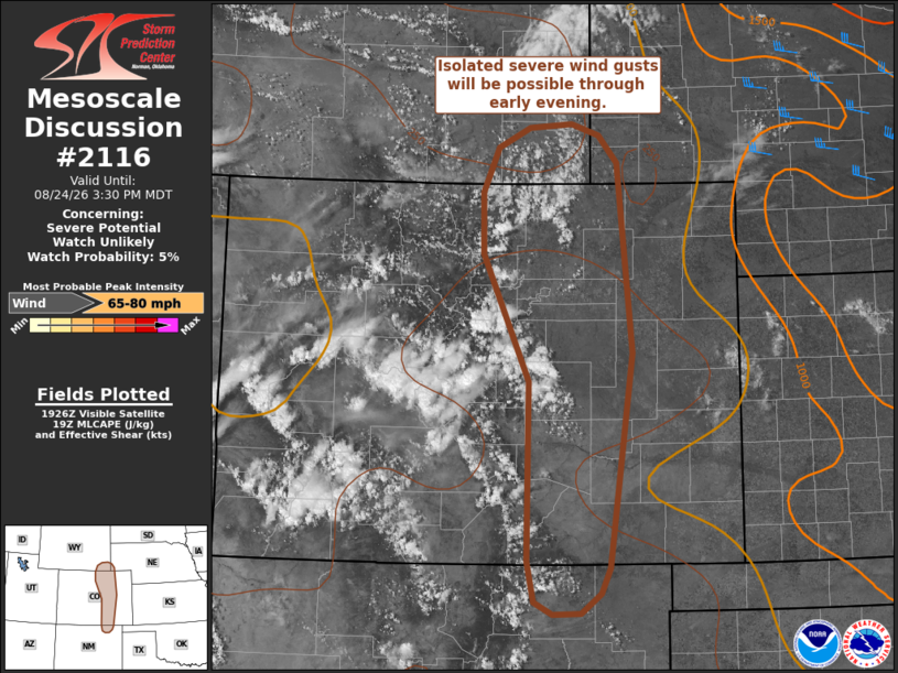
   Areas affected...Far southeast Wyoming into the Colorado Front Range
   and far northern New Mexico

   Concerning...Severe potential...Watch unlikely

   Valid 241936Z - 242130Z

   Probability of Watch Issuance...5 percent

   SUMMARY...High-based thunderstorms moving off the higher terrain of
   southeast Wyoming, central Colorado, and far north/northeast New
   Mexico will pose a risk of severe winds through early evening. Watch
   issuance is not expected given very limited buoyancy.

   DISCUSSION...Visible satellite imagery shows steady cumulus
   development along the CO Front Range within a weak upslope flow
   regime as well as across southeast WY in proximity to a weak
   low/mid-level MCV. Recent ACARs soundings from Denver, CO, along
   with the KFTG VWP, sampled 15-20 knot westerly flow within the
   CAPE-bearing layer that should promote eastward translation of
   convection off of the higher terrain through late afternoon. These
   soundings also sampled very dry boundary-layer conditions with LCLs
   just under 3 km. Although the very dry low-level conditions are
   limiting overall buoyancy magnitudes (SBCAPE is generally estimated
   to be around 250-500 J/kg per mesoanalysis and representative
   forecast soundings), they are highly favorable for intense
   downbursts capable of producing swaths of severe winds. This idea is
   reflected by a collection of recent CAM solutions, which generally
   depict sporadic swaths of 60-75 mph gusts as convection slowly
   intensifies and spreads east over the next few hours. The very
   limited CAPE and modest kinematic environment should modulate
   convective intensity and longevity (and preclude the need for a
   watch), and convection should steadily weaken in tandem with
   nocturnal cooling later this evening.

   ..Moore/Smith.. 08/24/2026

   ...Please see www.spc.noaa.gov for graphic product...

   ATTN...WFO...PUB...BOU...CYS...ABQ...

   LAT...LON   37030490 38920488 40250551 40910551 41380531 41580487
               41630430 41510394 41220368 40820364 39220349 36960379
               36680391 36480418 36470457 36600481 37030490

   MOST PROBABLE PEAK WIND GUST...65-80 MPH
|
|
|
Top/All Mesoscale Discussions/Forecast Products/Home |
|
Source link