

| Mesoscale Discussion 2109 | |
| < Previous MD | |

|
|
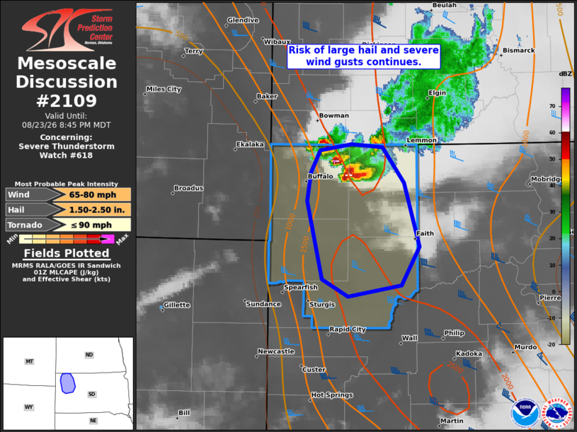
Mesoscale Discussion 2109 NWS Storm Prediction Center Norman OK 0813 PM CDT Sun Aug 23 2026 Areas affected...Parts of northwestern South Dakota Concerning...Severe Thunderstorm Watch 618... Valid 240113Z - 240245Z The severe weather threat for Severe Thunderstorm Watch 618 continues. SUMMARY...The risk of large hail and severe wind gusts should generally remain confined to parts of northwestern South Dakota in Severe Thunderstorm Watch 618. DISCUSSION...A discrete right-moving supercell (and upstream cell development) is tracking southward across far northwestern SD, with recent reports of large hail and a severe wind gust. In the near term, this activity will continue moving southward through a corridor of weak-moderate surface-based buoyancy and around 40 kt of effective shear. This environment will continue to support discrete supercells with a risk of large to very large hail and severe wind gusts. Eventually, these storms will move into an area of increasing low-level inhibition (sampled by the UNR 00Z sounding), which should limit the severe risk with southward extent. ..Weinman.. 08/24/2026 ...Please see www.spc.noaa.gov for graphic product... ATTN...WFO...BIS...UNR... LAT...LON 44620332 45390353 45660347 45880335 45950291 45920248 45560218 44940197 44560222 44450295 44620332 MOST PROBABLE PEAK TORNADO INTENSITY...UP TO 90 MPH MOST PROBABLE PEAK WIND GUST...65-80 MPH MOST PROBABLE PEAK HAIL SIZE...1.50-2.50 IN |
|
|
Top/All Mesoscale Discussions/Forecast Products/Home |
|
Source link