

| Mesoscale Discussion 2104 | |
| < Previous MD | |
|
|
   Mesoscale Discussion 2104
   NWS Storm Prediction Center Norman OK
   0431 PM CDT Sun Aug 23 2026

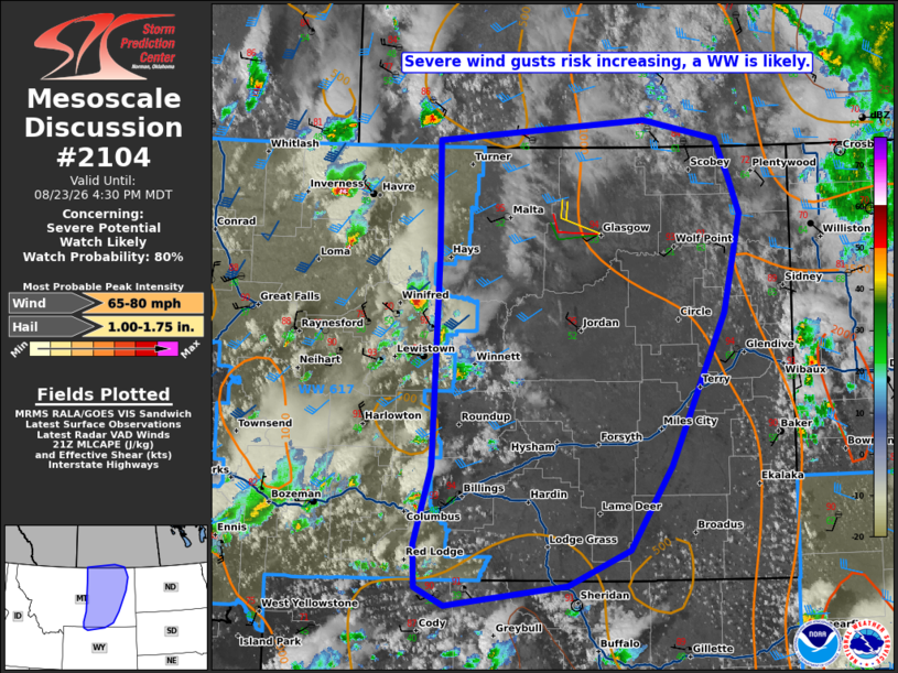
   Areas affected...portions of central and eastern Montana

   Concerning...Severe potential...Watch likely

   Valid 232131Z - 232230Z

   Probability of Watch Issuance...80 percent

   SUMMARY...Widely scattered thunderstorms (including some supercells)
   will continue eastward with a risk for severe gusts and isolated
   hail. A downstream Watch is likely needed.

   DISCUSSION...As of 2130 UTC, widely scattered thunderstorms were
   ongoing across central MT. New convection was also developing near
   the WY border. Ascent from an approaching upper trough should
   continue to support these storms and any new development this
   evening. Moisture is modest (40s and 50s F dewpoints), but strong
   diurnal heating has steepened low and mid-level lapse rates enough
   for moderate destabilization. This will support stronger updrafts as
   they move eastward over the next couple of hours. 40-50 kt of
   westerly flow aloft with supercells and some upscale growth into
   linear clusters. The dry sub-cloud layer and flow aloft will favor
   severe gusts, especially with clustering. Hail is also possible,
   especially with any persistent supercells. Given the increasing
   severe risk, a downstream Severe Thunderstorm Watch is likely needed
   soon.

   ..Lyons/Thompson.. 08/23/2026

   ...Please see www.spc.noaa.gov for graphic product...

   ATTN...WFO...BYZ...GGW...RIW...TFX...

   LAT...LON   49050884 49250603 49060504 48710487 48380473 47470496
               46050568 45270625 44940708 44760872 44920911 45330913
               46040889 48020883 49050884

   MOST PROBABLE PEAK WIND GUST...65-80 MPH
   MOST PROBABLE PEAK HAIL SIZE...1.00-1.75 IN
|
|
|
Top/All Mesoscale Discussions/Forecast Products/Home |
|
Source link