

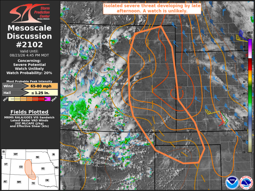
| Mesoscale Discussion 2102 | |
| < Previous MD | |

|
|
   Mesoscale Discussion 2102
   NWS Storm Prediction Center Norman OK
   0321 PM CDT Sun Aug 23 2026

   Areas affected...eastern Colorado...far southwest Kansas...and parts
   of the Oklahoma and Texas Panhandles

   Concerning...Severe potential...Watch unlikely

   Valid 232021Z - 232245Z

   Probability of Watch Issuance...20 percent

   SUMMARY...The threat for isolated severe storms capable of severe
   wind gusts up to 65-75 mph is expected to increase by late
   afternoon. A watch is unlikely due to the limited areal extent of
   the threat.

   DISCUSSION...Visible satellite and radar imagery indicate
   thunderstorms increasing in coverage along the CO Front Range and
   Sangre de Cristo Mountains within a mid-level moisture plume
   rotating around the northern periphery of an upper high. Objective
   analysis and the 18Z DDC observed sounding indicate residual capping
   in place across the adjacent plains of eastern CO with some
   deepening of cumulus noted along the Raton Mesa. Continued daytime
   heating will weaken the cap, allowing the mountain storms to spread
   east into the lower elevations. Additional storm development is also
   possible along a surface trough over eastern CO into the OK/TX
   Panhandles. The presence of steep low/mid-level lapse rates and up
   to 30 kt of deep-layer shear may support episodic storm organization
   through this evening with the primary hazard being severe wind gusts
   up to 65-75 mph.

   ..Mead/Smith.. 08/23/2026

   ...Please see www.spc.noaa.gov for graphic product...

   ATTN...WFO...DDC...GLD...AMA...PUB...BOU...ABQ...

   LAT...LON   38200426 39810434 40690404 40980276 40200222 39020203
               38210192 37360116 36350074 35840102 35820172 36320301
               37590407 38200426

   MOST PROBABLE PEAK WIND GUST...65-80 MPH
   MOST PROBABLE PEAK HAIL SIZE...UP TO 1.25 IN
|
|
|
Top/All Mesoscale Discussions/Forecast Products/Home |
|
Source link