

| Mesoscale Discussion 2099 | |
| < Previous MD Next MD > | |
|
|
   Mesoscale Discussion 2099
   NWS Storm Prediction Center Norman OK
   0219 PM CDT Sun Aug 23 2026

   Areas affected...Central Montana and adjacent portions of Idaho and
   northwest Wyoming

   Concerning...Severe potential...Watch possible

   Valid 231919Z - 232115Z

   Probability of Watch Issuance...60 percent

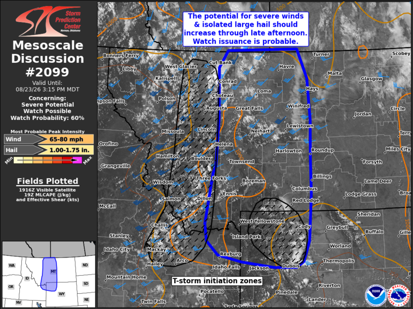
   SUMMARY...Thunderstorm development is expected in the coming hours
   within the northern Rockies. This activity will likely intensify as
   it spreads east across central Montana and portions of northwest
   Wyoming. Watch issuance is probable over portions of the region
   given the downstream convective environment.

   DISCUSSION...Growing cumulus is evident in latest GOES imagery
   within the higher terrain of northwest WY and eastern ID/western MT
   due to a combination of daytime heating and increasing ascent (both
   orographic and dynamic lift ahead of an approaching upper wave).
   Regional VWPs are also depicting increasing mid-level flow
   associated with the approach of the upper wave, resulting in gradual
   elongation of hodographs across the region. Concurrently,
   temperatures downstream across central MT are warming into the mid
   to upper 80s, which appears sufficient to erode lingering inhibition
   and support around 500-1000 J/kg MLCAPE based on modifications to
   forecast soundings. Consequently, it appears likely that
   thunderstorm development will occur in the coming hours as ascent
   continues to spread east over the destabilizing air mass.

   Recent guidance supports this notion and depicts initially
   discrete/semi-discrete cells across the region. This early activity
   will likely pose a threat for large hail (most likely 1 to 1.75 inch
   in diameter) given adequate hodograph elongation. With time,
   clustering and upscale growth should support an increasing wind
   threat across central MT through the late afternoon and evening
   hours. Based on the downstream environment and recent high-res
   guidance output, wind speeds up to 60-80 mph appear possible with
   the more intense/organized clusters. Watch issuance is probable in
   the next 1-2 hours as thunderstorms begin to develop and mature.

   ..Moore/Smith.. 08/23/2026

   ...Please see www.spc.noaa.gov for graphic product...

   ATTN...WFO...BYZ...GGW...RIW...TFX...PIH...

   LAT...LON   43580985 43721101 43891184 44241224 44671230 45951204
               46121196 47331187 48601189 49021155 49060898 48330862
               47280851 46360853 45420852 44250862 43730882 43580908
               43580985

   MOST PROBABLE PEAK WIND GUST...65-80 MPH
   MOST PROBABLE PEAK HAIL SIZE...1.00-1.75 IN
|
|
|
Top/All Mesoscale Discussions/Forecast Products/Home |
|
Source link