

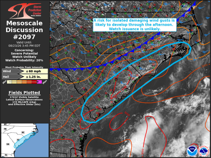
| Mesoscale Discussion 2097 | |
| < Previous MD | |

|
|
   Mesoscale Discussion 2097
   NWS Storm Prediction Center Norman OK
   1248 PM CDT Sun Aug 23 2026

   Areas affected...portions of the Carolina coastline into far eastern
   Georgia

   Concerning...Severe potential...Watch unlikely

   Valid 231748Z - 231945Z

   Probability of Watch Issuance...20 percent

   SUMMARY...Widely scattered thunderstorms may pose an isolated risk
   for damaging wind gusts and perhaps marginally severe hail. Watch
   issuance appears unlikely at this time.

   DISCUSSION...Latest surface analysis depicts a relatively diffuse
   cold front extending from the NC Coastal Plain into central South
   Carolina, with a deepening cumulus field and an inland-progressing
   sea breeze evident in visible satellite imagery ahead of this front.
   Widely scattered thunderstorm development is expected within this
   corridor over the next 1-2 hours. Hot and humid conditions (surface
   temperatures near 90 F and dewpoints in the mid 70s F) are already
   supporting 2000-3000+ J/kg, sufficient for at least a few robust
   updrafts. Isolated damaging wind gusts may accompany any stronger
   microbursts given modest PW (1.5-1.75 inches) and steepening
   low-level lapse rates within this moderate to strongly unstable
   environment. Despite relatively poor mid-level lapse rates, isolated
   marginally severe hail also cannot be ruled out (particularly along
   the northeastern SC and southeastern NC coastlines) with any
   transient supercell structure that can develop amid effective shear
   of around 35 kts. Trends will continue to be monitored, but watch
   issuance appears unlikely at this time as severe coverage and
   magnitude are expected to remain largely limited.

   ..Chalmers/Smith.. 08/23/2026

   ...Please see www.spc.noaa.gov for graphic product...

   ATTN...WFO...MHX...RAH...ILM...CHS...CAE...

   LAT...LON   32298023 31928084 31898110 31988142 32228156 32588148
               32908126 33528051 34337923 34927778 35127734 35257668
               35247640 35157619 34997606 34767616 34597648 34387697
               33777801 32957931 32497999 32298023

   MOST PROBABLE PEAK WIND GUST...UP TO 60 MPH
   MOST PROBABLE PEAK HAIL SIZE...UP TO 1.25 IN
|
|
|
Top/All Mesoscale Discussions/Forecast Products/Home |
|
Source link