

| Mesoscale Discussion 2096 | |
| < Previous MD | |

|
|
   Mesoscale Discussion 2096
   NWS Storm Prediction Center Norman OK
   1103 AM CDT Sun Aug 23 2026

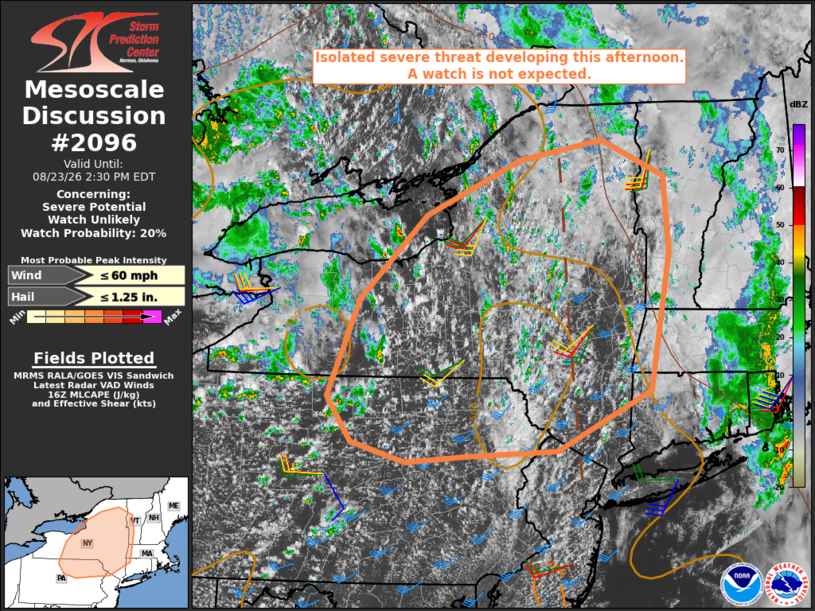
   Areas affected...northern Mid-Atlantic into western New England

   Concerning...Severe potential...Watch unlikely

   Valid 231603Z - 231830Z

   Probability of Watch Issuance...20 percent

   SUMMARY...A gradual increase in thunderstorm coverage is expected
   this afternoon along with a corresponding risk for isolated severe
   weather. A severe thunderstorm watch is not currently expected due
   to the limited nature of the threat.

   DISCUSSION...Ahead of a vorticity maximum pivoting from the lower
   Great Lakes into Hudson Valley, visible satellite and radar imagery
   indicate several areas of deepening moist convection. The 12Z
   Buffalo and Pittsburgh soundings indicate little to no capping with
   MLCAPE increasing to 1000-1500 J/kg by afternoon in areas that
   receive stronger heating. Accordingly, expect a gradual increase in
   thunderstorm coverage over the next few hours with the 12Z HREF
   calibrated thunder and paintball plots indicating the highest
   concentration of storms across the Hudson Valley this afternoon
   along a persistent zone of low-level confluence.

   Current VWPs and RAP-based forecast data indicate 30-35 kt of
   southwesterly deep-layer shear across the region; however, the
   vector orientation is expected to largely parallel that of the
   evolving convective bands, limiting the potential for a more
   organized damaging wind threat. Nonetheless, isolated occurrences of
   damaging wind gusts appear possible in areas where steeper low-level
   lapse rates can develop. Additionally, relatively cool mid-level
   temperatures will be supportive of a marginally severe hail risk
   with the strongest updrafts.

   ..Mead/Smith.. 08/23/2026

   ...Please see www.spc.noaa.gov for graphic product...

   ATTN...WFO...BTV...OKX...ALY...PHI...BGM...BUF...CTP...

   LAT...LON   41277764 41777799 42857754 43787654 44387515 44617391
               44207298 43377290 41847321 41197459 41137594 41057682
               41277764

   MOST PROBABLE PEAK WIND GUST...UP TO 60 MPH
   MOST PROBABLE PEAK HAIL SIZE...UP TO 1.25 IN
|
|
|
Top/All Mesoscale Discussions/Forecast Products/Home |
|
Source link