

| Mesoscale Discussion 2095 | |
| < Previous MD | |

|
|
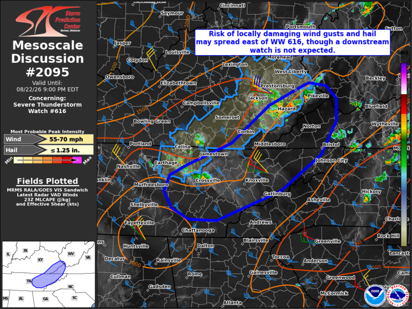
Mesoscale Discussion 2095 NWS Storm Prediction Center Norman OK 0637 PM CDT Sat Aug 22 2026 Areas affected...Portions of eastern KY...far western VA...and eastern TN Concerning...Severe Thunderstorm Watch 616... Valid 222337Z - 230100Z The severe weather threat for Severe Thunderstorm Watch 616 continues. SUMMARY...The risk of locally damaging wind gusts and hail may spread east of Severe Thunderstorm Watch 616 this evening, though a downstream watch is not expected. DISCUSSION...Along an eastward-moving cold front, two clusters of loosely organized thunderstorms in Middle TN and eastern KY are tracking east-southeastward toward the eastern edge of Severe Thunderstorm Watch 616 this evening. Around 30-40 kt of midlevel west-northwesterly flow (per JKL/OHX VWPs) oriented perpendicular to the front will aid in the maintenance of these storms for the next hour or so -- before reaching the higher terrain. This will especially be the case into eastern TN -- where lower/middle 80s temperatures and upper 60s dewpoints remain in place. As a result, the risk of locally damaging wind gusts and hail may spread east of the watch. However, given the localized nature of the ongoing severe risk, a downstream watch is not expected. ..Weinman.. 08/22/2026 ...Please see www.spc.noaa.gov for graphic product... ATTN...WFO...RNK...RLX...MRX...JKL...OHX... LAT...LON 36108557 36278521 36698420 37368336 37718261 37788245 37728207 37498184 37088184 36478219 35828309 35298452 35308514 35518552 35808569 36108557 MOST PROBABLE PEAK WIND GUST...55-70 MPH MOST PROBABLE PEAK HAIL SIZE...UP TO 1.25 IN |
|
|
Top/All Mesoscale Discussions/Forecast Products/Home |
|
Source link