

| Mesoscale Discussion 2094 | |
| < Previous MD Next MD > | |

|
|
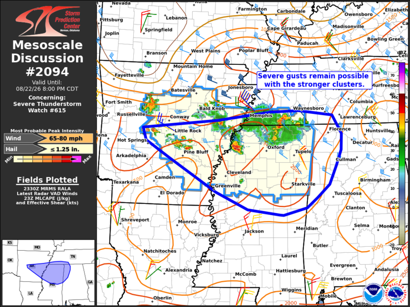
Mesoscale Discussion 2094 NWS Storm Prediction Center Norman OK 0633 PM CDT Sat Aug 22 2026 Areas affected...portions of eastern Arkansas...southwest Tennessee...northern Mississippi and Alabama Concerning...Severe Thunderstorm Watch 615... Valid 222333Z - 230100Z The severe weather threat for Severe Thunderstorm Watch 615 continues. SUMMARY...Several clusters of strong to severe storms continue over portions of WW615. Damaging winds remain possible with these storms. Some risk may continue into parts of northwestern AL this evening. DISCUSSION...As of 2330 UTC, regional radar showed several clusters of strong to severe storms ongoing across portions of WW615. The most intense of these clusters, located near the MS/TN border has produced recent measured severe gusts. This should continue across portions of southern TN and northern MS where moderate to large buoyancy and 25-35 kt of deep-layer shear are present and supporting more organized multicell clusters. High PWATS (2+ inches) and clustering will promote stronger downdrafts capable of damaging/isolated severe gusts. The primary severe risk appears most likely along the southwestern flank of the leading cluster across north-central MS where stronger low-level convergence along the existing outflow may preferentially support maintenance of the ongoing storms/new development this evening. However, some severe risk is possible east of WW615 into parts of northwestern AL this evening. However, the environment farther east is cooler and somewhat drier with less overall buoyancy. Weaker vertical shear with southward extent also casts some uncertainty on longevity. Regardless, enough buoyancy and steep low-level lapse rates likely exist to support an isolated damaging wind threat. ..Lyons.. 08/22/2026 ...Please see www.spc.noaa.gov for graphic product... ATTN...WFO...OHX...BMX...HUN...MEG...JAN...LZK... LAT...LON 35318939 35348856 35238754 34778728 34378730 33998745 33528765 33198802 32958832 32768902 32778913 32919006 33349101 34169239 34589310 34899320 35109096 35318939 MOST PROBABLE PEAK WIND GUST...65-80 MPH MOST PROBABLE PEAK HAIL SIZE...UP TO 1.25 IN |
|
|
Top/All Mesoscale Discussions/Forecast Products/Home |
|
Source link