

| Mesoscale Discussion 2091 | |
| < Previous MD Next MD > | |

|
|
   Mesoscale Discussion 2091
   NWS Storm Prediction Center Norman OK
   0502 PM CDT Sat Aug 22 2026

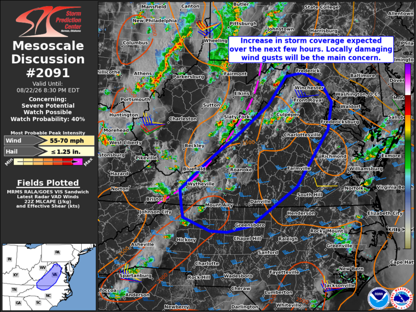
   Areas affected...Portions of western/central Virginia and northern
   North Carolina

   Concerning...Severe potential...Watch possible

   Valid 222202Z - 230030Z

   Probability of Watch Issuance...40 percent

   SUMMARY...Storms are expected to increase in coverage while
   spreading eastward into this evening. The primary concern is locally
   damaging wind gusts. While a watch is not currently expected, trends
   are being monitored.

   DISCUSSION...Thunderstorms are increasing in coverage along the Blue
   Ridge in western VA, potentially aided by increasing midlevel height
   falls preceding a broad midlevel trough approaching the region from
   the west. Over the next few hours, these storms should continue
   spreading eastward across western/central VA and northern NC. A
   warm, moist, and uncapped air mass downstream should support a
   modest increase in thunderstorm coverage. While midlevel lapse rates
   are limiting overall buoyancy (around 1000-1500 J/kg MLCAPE), an
   elongated midlevel hodograph (40 kt of 0-6 km shear per FCX VWP)
   could promote a few loosely organized clusters capable of producing
   locally damaging wind gusts. While the overall risk may remain too
   localized/sparse for a watch, trends are being monitored.

   ..Weinman/Thompson.. 08/22/2026

   ...Please see www.spc.noaa.gov for graphic product...

   ATTN...WFO...AKQ...LWX...RAH...RNK...GSP...

   LAT...LON   36568122 36908125 37628037 38057977 38737887 39377837
               39447792 39237739 38807712 38207722 36967810 36137933
               35987997 36008043 36298116 36568122

   MOST PROBABLE PEAK WIND GUST...55-70 MPH
   MOST PROBABLE PEAK HAIL SIZE...UP TO 1.25 IN
|
|
|
Top/All Mesoscale Discussions/Forecast Products/Home |
|
Source link