

| Mesoscale Discussion 2088 | |
| < Previous MD Next MD > | |

|
|
   Mesoscale Discussion 2088
   NWS Storm Prediction Center Norman OK
   0330 PM CDT Sat Aug 22 2026

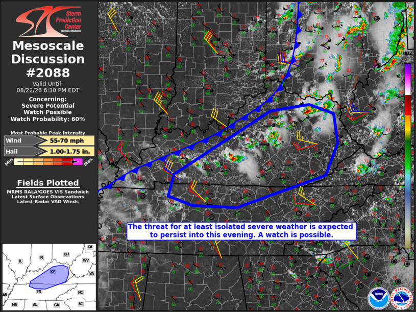
   Areas affected...portions of central and eastern Kentucky into
   northern middle Tennessee

   Concerning...Severe potential...Watch possible

   Valid 222030Z - 222230Z

   Probability of Watch Issuance...60 percent

   SUMMARY...The threat for at least isolated severe storms is expected
   to persist through this evening. Convective trends are being
   monitored for a possible severe thunderstorm watch.

   DISCUSSION...Over the past hour, thunderstorms have gradually
   increased in areal coverage from northeast into central KY, ahead of
   a cold front advancing into the northern part of the state. The
   inflow air mass to these storms is relatively hot and moist, leading
   to steep low-level lapse rates and MLCAPE ranging from around 1000
   J/kg in northeast KY to as high as 2500-3000 J/kg near the
   confluence of the Mississippi and Ohio Rivers.

   Regional VWPs indicate gradually strengthening mid and upper-level
   winds this afternoon with deep-layer shear vectors oriented largely
   perpendicular to the surface front, especially over western and
   central KY. That is resulting in a semi-discrete storm mode with
   recent reports of hail up to one inch. Further strengthening of
   deep-layer shear is forecast through the remainder of the afternoon,
   potentially leading to a greater supercell and associated large-hail
   threat. Damaging wind potential may tend to increase by early
   evening, especially if some clustering of storms can occur.

   ..Mead/Smith.. 08/22/2026

   ...Please see www.spc.noaa.gov for graphic product...

   ATTN...WFO...RLX...MRX...JKL...ILN...LMK...OHX...PAH...

   LAT...LON   36878749 36948734 38378467 38518352 38288280 37598271
               36858308 36118565 36138691 36348764 36878749

   MOST PROBABLE PEAK WIND GUST...55-70 MPH
   MOST PROBABLE PEAK HAIL SIZE...1.00-1.75 IN
|
|
|
Top/All Mesoscale Discussions/Forecast Products/Home |
|
Source link