

| Mesoscale Discussion 2086 | |
| < Previous MD Next MD > | |
|
|
   Mesoscale Discussion 2086
   NWS Storm Prediction Center Norman OK
   0246 PM CDT Sat Aug 22 2026

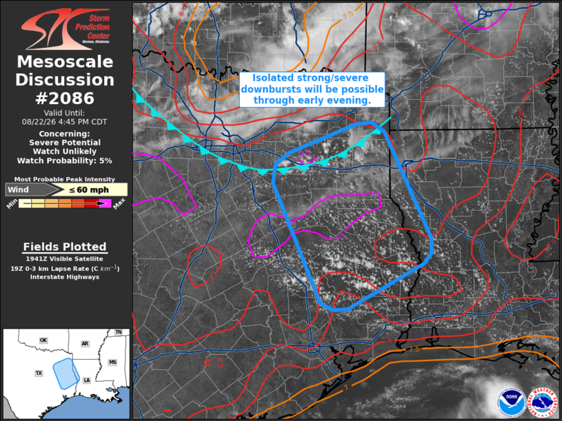
   Areas affected...Eastern Texas into far western Louisiana

   Concerning...Severe potential...Watch unlikely

   Valid 221946Z - 222145Z

   Probability of Watch Issuance...5 percent

   SUMMARY...Isolated thunderstorms will be capable of strong to severe
   downburst winds through early evening across eastern Texas and far
   western Louisiana. This threat should be sufficiently isolated to
   preclude watch issuance.

   DISCUSSION...A recent 18 UTC sounding from SHV sampled very limited
   inhibition remaining across far west/northwest LA. Further west into
   eastern TX, temperatures are much warmer (100-106 F) with dewpoints
   in the mid to upper 60s. Modifying the SHV sounding suggests that
   SBCAPE values are likely approaching 3500 J/kg - much higher than
   depicted by recent mesoanalysis estimates - with virtually no
   lingering inhibition. Recent GOES imagery also shows an expanding
   and deepening cumulus field across eastern TX, bounded to the north
   by a residual outflow boundary and to the west by warmer 925-850 mb
   temperatures/capping. Consequently, a corridor appears to be
   emerging across east TX into western LA where thunderstorm
   development is likely in the coming hours.

   Weak forcing for ascent (mainly driven by weak low-level confluence
   and/or strong surface heating) suggests that overall storm coverage
   should remain somewhat limited. However, a combination of weak
   deep-layer shear, steep low-level lapse rates on the order of 8-9
   C/km, strong buoyancy, and 1.8 to 2.0 inch PWAT values should
   support robust, water-loaded updraft development followed by strong
   downbursts. Recent high-res ensemble guidance hints at this
   potential and suggests localized swaths of 45-60 mph winds are
   possible. This activity should peak by 4-6 PM CDT before gradually
   diminishing with the loss of daytime heating after around 8 PM.
   Trends will be monitored, but the expectation for more limited storm
   coverage should negate the need for a watch.

   ..Moore/Smith.. 08/22/2026

   ...Please see www.spc.noaa.gov for graphic product...

   ATTN...WFO...LCH...SHV...HGX...FWD...

   LAT...LON   32669584 33119464 33139436 33009413 31379332 31159333
               31009346 30339478 30329506 30429526 32229611 32509607
               32669584

   MOST PROBABLE PEAK WIND GUST...UP TO 60 MPH
|
|
|
Top/All Mesoscale Discussions/Forecast Products/Home |
|
Source link