

| Mesoscale Discussion 2085 | |
| < Previous MD Next MD > | |

|
|
   Mesoscale Discussion 2085
   NWS Storm Prediction Center Norman OK
   0218 PM CDT Sat Aug 22 2026

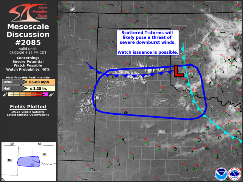
   Areas affected...Southern Texas Panhandle into far southwest
   Oklahoma

   Concerning...Severe potential...Watch possible

   Valid 221918Z - 222115Z

   Probability of Watch Issuance...40 percent

   SUMMARY...Thunderstorm development is anticipated across far
   southwest Oklahoma and into the Texas Panhandle/northwest Texas by
   late afternoon. This activity will pose a threat for severe
   downburst winds as it spreads southwest through early evening. Watch
   issuance is possible.

   DISCUSSION...Recent surface observations are reporting temperatures
   reaching into the 106-110 F range within the apex of a thermal ridge
   across northwest TX. These temperatures are running 4-5 F warmer
   than expected based on the latest high-res guidance, which implies
   that boundary-layer mixing is likely deeper than depicted by
   forecast soundings. Similarly, residual mixed-layer inhibition is
   likely weaker than recent RAP mesoanalyses would suggest. The early
   stages of boundary-layer cumulus development are becoming evident in
   GOES imagery, suggesting that thunderstorm development appears
   probable in the coming hours either along a residual outflow
   boundary draped across southwest OK, along a diffuse/weak frontal
   zone extending into the TX Panhandle, or in proximity to a weak
   thermal low analyzed near the intersection of these two boundaries.

   Although recent guidance does not appear to be capturing low-level
   thermodynamic conditions well, HRRR/RRFS time-lagged guidance shows
   a trends towards widely scattered to scattered thunderstorm
   development by the 20-22 UTC period. Deep-layer shear will remain
   weak and promote mainly disorganized convection, but the potential
   for severe downbursts should increase as thunderstorms spread
   south/southwest into the thermal ridge where low-level profiles will
   be most optimal for near-surface downdraft accelerations. Explicit
   wind gusts estimates from high-res solutions depict small swaths of
   60-75 mph winds, which appear reasonable given the expectation of
   poorly organized convection within a very hot/deeply mixed
   environment. Convective trends will continue to be monitored, and
   watch issuance is possible if convective coverage appears sufficient
   for a more widespread severe wind threat.

   ..Moore/Smith.. 08/22/2026

   ...Please see www.spc.noaa.gov for graphic product...

   ATTN...WFO...OUN...LUB...AMA...ABQ...

   LAT...LON   33469894 33419928 33610233 33640275 33720299 33900312
               34150316 34500308 34810289 35060253 35130166 35160062
               35269914 35149890 34869876 33819857 33609867 33469894

   MOST PROBABLE PEAK WIND GUST...65-80 MPH
   MOST PROBABLE PEAK HAIL SIZE...UP TO 1.25 IN
|
|
|
Top/All Mesoscale Discussions/Forecast Products/Home |
|
Source link