

| Mesoscale Discussion 2084 | |
| < Previous MD Next MD > | |

|
|
   Mesoscale Discussion 2084
   NWS Storm Prediction Center Norman OK
   0215 PM CDT Sat Aug 22 2026

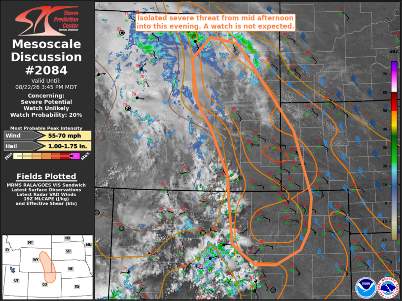
   Areas affected...portions of central and eastern Wyoming into the
   western Nebraska Panhandle and northeast Colorado

   Concerning...Severe potential...Watch unlikely

   Valid 221915Z - 222145Z

   Probability of Watch Issuance...20 percent

   SUMMARY...The threat for isolated occurrences of large hail and
   severe wind gusts is expected to increase by mid-afternoon and
   continue through this evening. A watch is currently not anticipated
   due to the limited coverage of the threat.

   DISCUSSION...Recent trends in visible satellite imagery show
   deepening moist convection along the Laramie Mountains and CO Front
   Range with additional development likely ahead of a well-defined MCV
   moving through central WY. Beneath a plume of steep mid-level lapse
   rates, current surface observations indicate a moist boundary layer
   characterized by dewpoints in the mid 50s to low 60s, yielding
   MLCAPE of 1000-1500 J/kg. Latest objective analysis suggests the air
   mass across the adjacent High Plains remains capped; however,
   continued daytime heating and the glancing influence of the WY MCV
   should allow initial terrain-anchored storms to move into lower
   elevations later this afternoon into evening.

   Current VWPs and RAP-based forecast soundings indicate vertically
   veering wind profiles with around 30 kt of deep-layer shear, which
   will be supportive of at least episodic supercell structures capable
   of large hail. The potential for isolated severe wind gusts may
   become more likely by early evening, especially if storms can merge
   into clusters.

   ..Mead/Smith.. 08/22/2026

   ...Please see www.spc.noaa.gov for graphic product...

   ATTN...WFO...UNR...BOU...CYS...RIW...

   LAT...LON   39800550 41380567 42410617 42980659 43970678 44480622
               44330536 43750482 42360365 40850314 40080324 39670350
               39320422 39330484 39800550

   MOST PROBABLE PEAK WIND GUST...55-70 MPH
   MOST PROBABLE PEAK HAIL SIZE...1.00-1.75 IN
|
|
|
Top/All Mesoscale Discussions/Forecast Products/Home |
|
Source link