

| Mesoscale Discussion 2082 | |
| < Previous MD | |
|
|
   Mesoscale Discussion 2082
   NWS Storm Prediction Center Norman OK
   0109 PM CDT Sat Aug 22 2026

   Areas affected...portions of the Mid South

   Concerning...Severe potential...Watch likely

   Valid 221809Z - 222015Z

   Probability of Watch Issuance...80 percent

   SUMMARY...Scattered damaging/severe wind gusts and isolated large
   hail are expected across portions of the Mid South this afternoon. A
   Severe Thunderstorm Watch will likely be needed.

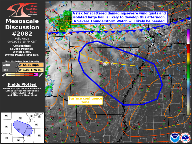
   DISCUSSION...Latest surface analysis depicts a west-east oriented
   cold front extending from far southern Illinois into southern
   Missouri and Kansas. Also evident in visible satellite imagery are
   an MCV located in close proximity to ongoing convection across far
   southeastern Kansas and a surface confluence zone across northern
   Arkansas demarcated by a zone of developing cumulus. As this MCV and
   surface cold front continue to progress south-southeastward through
   mid-afternoon, guidance suggests that ongoing convection should
   intensify and/or additional development will occur along the
   aforementioned boundaries amid a moderately unstable environment.

   As convective coverage increases through the mid-afternoon, enhanced
   mid-level flow associated with the MCV (40-50 kts sampled by the
   Tulsa/Wichita VWPs along the southern flank of the MCV) will aid in
   the organization of convection into one or more linear clusters.
   Scattered damaging/severe wind gusts (and potentially a few
   significant gusts to 75-80 mph) are likely to accompany this cluster
   given the enhanced mid-level flow and presence of very steep
   low-to-mid level lapse rates below 600 mb (as depicted by recent
   objective analysis and sampled by the 12 UTC LZK observed sounding).
   A Severe Thunderstorm Watch will likely be needed in the next 1-2
   hours to address this severe risk.

   ..Chalmers/Smith.. 08/22/2026

   ...Please see www.spc.noaa.gov for graphic product...

   ATTN...WFO...MEG...JAN...LZK...SGF...TSA...

   LAT...LON   35779399 35159363 34349252 33509112 33518998 33788906
               34528871 34998886 35608919 36039020 36829284 36679353
               36239395 35779399

   MOST PROBABLE PEAK WIND GUST...65-80 MPH
   MOST PROBABLE PEAK HAIL SIZE...1.00-1.75 IN
|
|
|
Top/All Mesoscale Discussions/Forecast Products/Home |
|
Source link