

| Mesoscale Discussion 2081 | |
| < Previous MD | |
|
|
   Mesoscale Discussion 2081
   NWS Storm Prediction Center Norman OK
   1038 AM CDT Sat Aug 22 2026

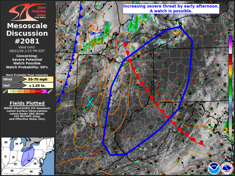
   Areas affected...central and eastern Ohio...eastern
   Kentucky...northern and western West Virginia...and western parts of
   Pennsylvania and New York

   Concerning...Severe potential...Watch possible

   Valid 221538Z - 221815Z

   Probability of Watch Issuance...60 percent

   SUMMARY...The threat for at least isolated severe storms is expected
   to increase by early afternoon. A severe thunderstorm watch is
   possible by as early as 17-18Z.

   DISCUSSION...Mid-morning visible satellite imagery shows a
   well-defined MCV over southwest OH with an associated zone of
   forcing for ascent contributing to some light shower activity north
   of Columbus. The 12Z ILN sounding sampled a relatively deep moisture
   profile in the low levels, which yielded MUCAPE of 1500-2500 J/kg.
   That moisture will combine with strong daytime heating ahead of the
   central OH convection to support a moderately unstable air mass by
   afternoon for surface-based parcels with MLCAPE increasing to
   1500-2000 J/kg. That destabilization process coupled with the
   forcing ahead of the MCV is expected to foster a gradual increase in
   storm coverage and intensity by early afternoon.

   Current VWP and RAP-based sounding data indicate the strongest
   mid/upper-level winds and resultant deep-layer shear remaining west
   of the effective warm sector, which may tend to limit the
   organization and longevity of individual storms. Nonetheless,
   steepening low-level lapse rates within the inflow region of the
   expected storms may enhance damaging wind potential, especially in
   areas where storm clusters and/or line segments can evolve.
   Marginally severe hail may also accompany the strongest storms.

   ..Mead/Smith.. 08/22/2026

   ...Please see www.spc.noaa.gov for graphic product...

   ATTN...WFO...BUF...CTP...LWX...PBZ...RLX...CLE...JKL...ILN...

   LAT...LON   39088308 40368287 41518219 42248090 42787980 42927899
               42307830 41197846 40497862 39417918 38578021 38118094
               37508202 37468283 37978326 39088308

   MOST PROBABLE PEAK WIND GUST...55-70 MPH
   MOST PROBABLE PEAK HAIL SIZE...UP TO 1.25 IN
|
|
|
Top/All Mesoscale Discussions/Forecast Products/Home |
|
Source link