

| Mesoscale Discussion 2079 | |
| < Previous MD | |

|
|
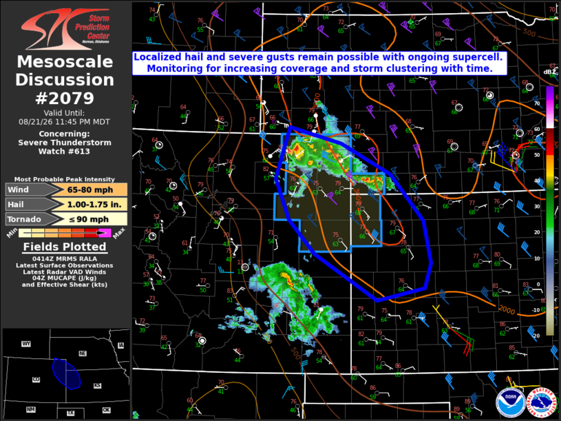
Mesoscale Discussion 2079 NWS Storm Prediction Center Norman OK 1116 PM CDT Fri Aug 21 2026 Areas affected...Parts of northeast CO...southwest NE...western KS Concerning...Severe Thunderstorm Watch 613... Valid 220416Z - 220545Z The severe weather threat for Severe Thunderstorm Watch 613 continues. SUMMARY...An isolated severe threat will continue with an ongoing supercell. Trends are being monitored for any storm clustering with time. DISCUSSION...An ongoing supercell across northeast CO will continue to pose a short-term threat for localized hail and severe gusts as it moves south-southeastward. Recent objective mesoanalyses depict an 850-mb moisture axis extending southeast from ongoing convection into northwest KS, and recent VWPs from KGLD indicate a strengthening nocturnal low-level jet. These factors may allow for some increase in storm coverage and clustering (as depicted by some recent HRRR/RRFS runs), within a favorably unstable (MUCAPE of 2000-3000 J/kg) and sufficiently sheared environment. However, the current isolated nature of the ongoing threat and increasing MLCINH with time result in uncertainty regarding overnight severe potential downstream. Some increase in elevated storm coverage has recently been noted over far southwest NE, and if convection can continue to increase in coverage later tonight, then steep lapse rates above the surface and relatively large DCAPE could support modest cold pool generation and an increasing severe-wind threat, despite increasing near-surface stability. Local watch expansion and/or new watch issuance will be possible if trends support an increasing downstream severe threat overnight. ..Dean/Thompson.. 08/22/2026 ...Please see www.spc.noaa.gov for graphic product... ATTN...WFO...LBF...DDC...GLD...PUB...BOU...CYS... LAT...LON 41120338 40850226 40320117 39550048 38840033 38410047 38210148 39000283 39570339 40260368 41120338 MOST PROBABLE PEAK TORNADO INTENSITY...UP TO 90 MPH MOST PROBABLE PEAK WIND GUST...65-80 MPH MOST PROBABLE PEAK HAIL SIZE...1.00-1.75 IN |
|
|
Top/All Mesoscale Discussions/Forecast Products/Home |
|
Source link