

| Mesoscale Discussion 2074 | |
| < Previous MD | |
|
|
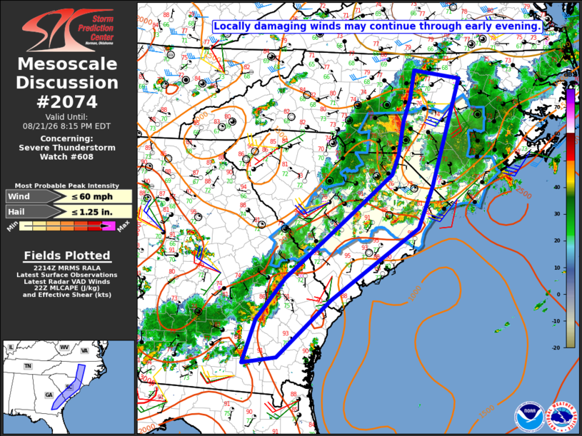
Mesoscale Discussion 2074 NWS Storm Prediction Center Norman OK 0516 PM CDT Fri Aug 21 2026 Areas affected...Southeast GA into parts of the Carolinas Concerning...Severe Thunderstorm Watch 608... Valid 212216Z - 220015Z The severe weather threat for Severe Thunderstorm Watch 608 continues. SUMMARY...Locally damaging wind may continue through the early evening. DISCUSSION...Extensive deep convection is ongoing from southeast GA into parts of the Carolinas, which earlier produced scattered reports of wind damage through the afternoon. While storm organization has generally been limited by weak to modest deep-layer shear, a relatively vigorous line is ongoing east of Charlotte to Greensboro, NC. A narrow plume of moderate buoyancy in advance of this line will continue to support a short-term wind-damage threat. However, the longevity of the threat with this line may be limited by the relatively cooler and less unstable conditions downstream, due to earlier convection and related outflow. Otherwise, sporadic wind damage remains possible from southeast GA into eastern SC< where deep-layer shear is weak, but a corridor of warmer temperatures and steeper low-level lapse rates will remain in place through early evening, in advance of ongoing storms. ..Dean.. 08/21/2026 ...Please see www.spc.noaa.gov for graphic product... ATTN...WFO...RAH...ILM...RNK...CHS...CAE...JAX...FFC... LAT...LON 31888260 32608200 33738062 34427978 34777964 35367954 35747940 36247930 36107835 34207893 33487924 32228106 31228217 31118287 31888260 MOST PROBABLE PEAK WIND GUST...UP TO 60 MPH MOST PROBABLE PEAK HAIL SIZE...UP TO 1.25 IN |
|
|
Top/All Mesoscale Discussions/Forecast Products/Home |
|
Source link